Geomaticians

30

EuroGeographics And International Cartographic Association Agree Collaboration To Unlock Power Of Location

EuroGeographics And International Cartographic Association Agree Collaboration To Unlock Power Of Location

Experts in authoritative geospatial data, cartography and GIScience have today (29 August 2023) announced a new international collaboration to demonstrate the power of location. Members of EuroGeographics, the not-for-profit association for European National Mapping, Cadastral and Land Registration Authorities, and the International Cartographic Association (ICA) will use their collective expertise to support the public good. ...
directionsmag.com

Dry Farm Researchers’ New Mapping Project Will Give Oregon Growers A Resource

As growing seasons become hotter and drier across the region, farmers are increasingly challenged to grow and sustain their crops. Now Oregon State University is close to launching a dry farming map project. Lucas Nebert, a research associate at OSU, heads the project. He told KLCC that a lot of farmers are interested in alternatives ...
opb.org
Alberta Scientists Tracking Blue-green Algae Blooms Using Satellite Imagery_gge

Alberta Scientists Tracking Blue-Green Algae Blooms Using Satellite Imagery

A team of experts is working to better understand the spread of blue-green algae in Alberta lakes by combining satellite technology with near-simultaneous water sampling. The project, funded through Alberta Innovates, is a collaboration between several groups, including Alberta Lake Management Society (ALMS), the Alberta Biodiversity Monitoring Institute (ABMI), and researcher Rolf Vinebrooke from the ...
cbc.ca
TEMPO - Nitrogen Dioxide Air Pollution Over North America

TEMPO – Nitrogen Dioxide Air Pollution Over North America

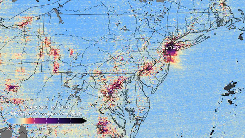
The Tropospheric Emissions: Monitoring of Pollution (TEMPO) instrument collected its “first light” measurements of nitrogen dioxide air pollution over North America on August 2, 2023. Beginning at 11:15 AM Eastern Daylight Time (8:15 AM Pacific Time), the instrument scanned the continent every hour for six consecutive hours. TEMPO measures sunlight reflected and scattered off the ...
svs.gsfc.nasa.gov