Geomaticians

08

Bluesky Metrovista 3D City Model Underpins Nottingham’s Digital Twin

Bluesky Metrovista 3D City Model Underpins Nottingham’s Digital Twin

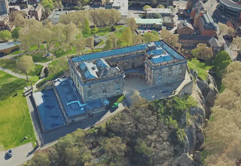
Nottingham City Council is a step closer to achieving its vision of creating a digital twin for the city. In what’s believed to be a UK first they are combining the intricate, rich MetroVista 3D mesh with existing photogrammetric 3D modelling within the same application. This enables the visualisation of new developments in an immersive ...
directionsmag.com

Nowe Regulacje Usprawnią Standaryzację Zbiorów Danych Przestrzennych

Na stronach Rządowego Centrum Legislacji pojawił się projekt zmiany rozporządzenia Ministra Rozwoju i Technologii, który stawia ważny krok w kierunku standaryzacji tworzonych zbiorów danych przestrzennych. Zmiany dotyczącą dokładnie projektu regulacji zmieniających rozporządzenie w sprawie zbiorów danych przestrzennych oraz metadanych w zakresie zagospodarowania przestrzennego(1). Jego celem jest aktualizacja oraz rozszerzenie regulacji w zakresie tworzenia zbiorów obejmujących ...
teraz-srodowisko.pl
Austria Publishes Map Of Locations With Available Grid Capacity For PV

Austria Publishes Map Of Locations With Available Grid Capacity For PV

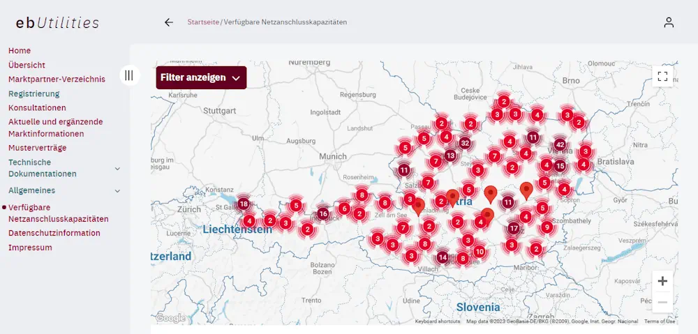
The Austrian government introduced the Electricity Industry and Organization Act (ElWOG) two years ago, leading to the creation of a map of locations with available grid capacity for solar. The ElWOG require grid operators to be transparent about grid-connection capacity. Oesterreich Energie will update the map on a quarterly basis, by using reports from Austrian ...
pv-magazine.com

Orman Yangınlarıyla Mücadelede “Yapay Zeka” Desteği Artıyor

Bakanlık orman yangınlarıyla mücadelede üst düzey teknolojik sistemlerden faydalanarak projeler geliştiriyor. Bu kapsamda, Orman Genel Müdürlüğü ve özel sektör işbirliğiyle yapay zeka destekli “Yangın Risk Yönetimi Projesi” uygulanıyor. Projeyle orman yangınlarının önceden tahmin edilebilmesine yönelik çalışmalar yapılarak bu bölgelerde gerekli önlemler alınmaya çalışılıyor. Çeşitli faktörler göz önünde bulundurularak geliştirilen projeyle meteorolojik veriler, bitki örtüsü, topografya, ...
aa.com.tr
NOAA Eliminates Certain Restrictions On Commercial Remote Sensing Companies

The U.S. government lifted certain restrictions on commercial remote sensing satellite companies on Monday. The changes came from NOAA’s Commercial Remote Sensing Regulatory Affairs (CRSRA) office, which is a division of the Office of Space Commerce. CRSA said restrictions in place kept companies from offering their full capabilities to the public. In 2020, CRSA changed ...
satellitetoday.com
Hong Kong's First-ever And One Of The World's Largest Satellite Manufacturing Facilities To Deliver First Satellite By 2024

Hong Kong’s First-ever And One Of The World’s Largest Satellite Manufacturing Facilities To Deliver First Satellite By 2024

China’s Hong Kong Special Administrative Region (HKSAR) has newly launched the city’s first and one of the world’s largest satellite manufacturing facilities, known as AMC. The facility revealed to the Global Times in an exclusive interview that their first made-in-Hong Kong, high-quality satellite would hopefully be delivered by the beginning of 2024. Referred also as ...
globaltimes.cn

Russia Launches Newly Redesigned Navigation Satellite

The first GLONASS-K2 satellite finally reached the launch status in the middle of 2023, or a decade behind the original schedule. At the end of July 2023, the adminstration of the Safronovskoe settlement in the Lensk District in the Arkhangelsk Region (Oblast) posted a letter from the Deputy Commander of the Russian Space Forces, VKS, ...
russianspaceweb.com

NextNav Completes Initial Tests For 3D Poisition, Navigation And Timing Service

The solution combines NextNav’s reliable TerraPoiNT system with existing LTE and 5G network signals. The tests, conducted in and around San Jose, California, US, showcased the integration of TerraPoiNT signals with cellular infrastructure to deliver highly accurate 3D positioning and timing information without depending solely on traditional satellite-based GPS and GNSS signals. NextNav’s system utilises ...
construction-europe.com
Roman Road Network Spanning The South West Identified In New Research

Roman Road Network Spanning The South West Identified In New Research

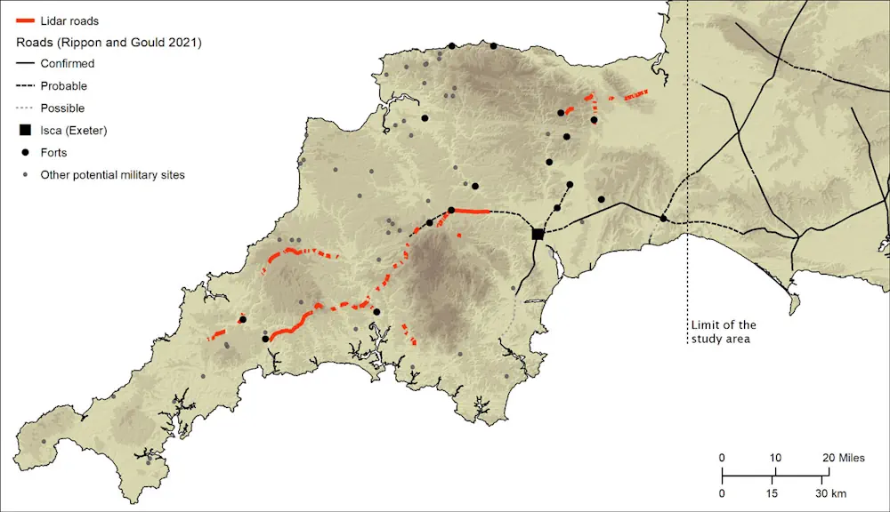
Archaeologists at the University of Exeter have used laser scans collected as part of the Environment Agency’s National LiDAR Programme to identify new sections of road west of the previously understood boundary. Among the things it reveals is that far from Exeter being the main nerve centre of the network, it was North Tawton that ...
sciencedaily.com
Modelo Geoespacial Analisa A Relação Custo-benefício Dos Telhados Verdes Nas Cidades

Modelo Geoespacial Analisa A Relação Custo-benefício Dos Telhados Verdes Nas Cidades

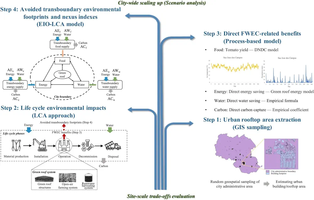
Telhados verdes têm sido apontados como uma das possíveis soluções para o combate às mudanças climáticas nas cidades. Isso porque, além de permitirem a captação de água da chuva e a produção de hortaliças no alto dos edifícios, eles também são capazes de gerar microclima, reduzindo a temperatura local e o gasto energético com refrigeração, ...
mundogeo.com
Butterflies Can Remember Where Things Are Over Sizeable Spaces, Study Finds

Butterflies Can Remember Where Things Are Over Sizeable Spaces, Study Finds

Heliconius butterflies are capable of spatial learning, scientists have discovered. The findings, published in Current Biology, also suggest Heliconius butterflies may be able to learn spatial information at large scales, consistent with the apparent importance of long-range spatial learning for traplining, which involves foraging within a home range of a few hundred square meters. Spatial ...
bristol.ac.uk