Geomaticians

05

Índice De Clasificaciones De Agua Superficial Desde El Espacio Landsat 2022

El Instituto Nacional De Estadística Y Geografía (INEGI) Pone A Disposición De Las Y Los Usuarios El Índice De Clasificaciones De Agua Superficial Desde El Espacio (ICASE) Landsat 2022. Este Consiste En Un Producto De Análisis Geoespacial Experimental Que Proporciona Información Sobre La Presencia De Agua Superficial A Lo Largo De Todo El Territorio Mexicano. ...
journalmex.com.mx

Russian Gov’t Agencies Banned From Using Foreign Geospatial Systems

Russian President Vladimir Putin signed a law prohibiting government agencies and a number of organizations from using foreign geospatial systems, technologies, and tools, local media reported on Saturday. According to RIA Novosti, the ban will apply to state corporations, public companies, and natural monopolies. The ban will also affect business entities in the authorized capital ...
english.news.cn
Capella’s Earth-Imaging Satellites Are Deorbiting Faster Than Expected

Capella Space’s synthetic aperture radar satellites are falling back to Earth much sooner than the three years they were anticipated to operate, according to publicly available satellite data. The startup has launched a total of ten small satellites to low Earth orbit since 2018, including eight in its family of “Whitney”-class spacecraft. Five of these ...
techcrunch.com
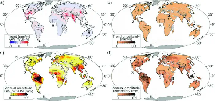
Naukowcy Z WAT Proponują, By Wykorzystać GPS W Monitorowaniu Poziomu Wód Podziemnych

Naukowcy Z WAT Proponują, By Wykorzystać GPS W Monitorowaniu Poziomu Wód Podziemnych

Naukowcy z Wojskowej Akademii Technicznej zaproponowali innowacyjną metodę pomiaru ubożenia wód podziemnych opartą na pomiarach GPS. To, jak zmienia się poziom wód podziemnych, będzie można monitorować zdalnie – nawet w najbardziej odległych częściach świata. Mimo że techniki teledetekcyjne się rozwijają, a obserwacje naziemne stają się coraz dokładniejsze, modele opisujące poziom wód gruntowych nadal nie są ...
portalsamorzadowy.pl
Beating The Heat Students Map California Tree Canopy To Cool Cities As Climate Warms

Beating The Heat: Students Map California Tree Canopy To Cool Cities As Climate Warms

This summer, a group of students are embarking on a groundbreaking project: mapping tree canopy cover in California. Tree canopies, which provide shade, can offset the heat island effect in cities. The effect is caused by buildings, roads and other human-made infrastructure absorbing and then re-emitting heat. In a warming climate, the heat island effect ...
calpoly.edu