Geomaticians

01

Ambiente, Da ENEA Mappa Aree Costiere A Rischio Inondazioni

ENEA ha sviluppato un nuovo servizio in grado di mappare le aree costiere a rischio inondazione per il cambiamento climatico che abbina modelli ad alta risoluzione, tecnologie satellitari e rilievi sul campo. Messo a punto da un team di ricercatori composto da climatologi, esperti GIS, oceanografi e geologi, è stato presentato al XXI Congresso International ...
finanza.lastampa.it
Paris City Hall Supports An Interactive Map Of 1-euro Coffee In The City

Paris City Hall Supports An Interactive Map Of 1-euro Coffee In The City

The rising inflation in the past year has caused coffee and espresso prices to double or triple (these days, the common cost for these is well over 2 euros). Despite this, some establishments have said “non” and have maintained affordability. This interactive map shows all of the bars, restaurants and cafes in Paris where you ...
themayor.eu

City Police Geotagging 23,000-plus Surveillance Cameras In Coimbatore

Feeds from surveillance cameras play a key role in tracing and identifying individuals and vehicles during investigations. But locating cameras in a given location after the occurrence of a crime or accident often causes delay in the investigation. Now, the Coimbatore City Police are in the process of cutting down this delay by geotagging all ...
thehindu.com
Hilfe In Der Not Diese Karte Zeigt, Wie Lange Die Polizei Wirklich Braucht

Hilfe In Der Not: Diese Karte Zeigt, Wie Lange Die Polizei Wirklich Braucht

Bei einem Polizeieinsatz kommt es oft auf jede Minute an. Manche Stimmen behaupten jedoch, dass die Polizei in Deutschland meist erst dann komme, wenn es schon zu spät ist. Es scheint ein Gefälle zwischen echter und gefühlter Sicherheit zu geben. Aber ist das alles nur ein Bauchgefühl oder eine belegbare Tatsache? Die Online-Karte zur Erreichbarkeit ...
chip.de

El Proyecto ‘MoniCa’ Finaliza Tras Desarrollar Una Plataforma De Agromonitorización De Cultivos Extensivos

El consorcio del grupo operativo ‘MoniCa’, formado por el Departamento de Geografía Física y Análisis Geográfico Regional de la Universidad de Sevilla (US), Emergya Grupo, Asaja-Cádiz y CTA (Corporación Tecnológica de Andalucía), ha recibido financiación para este proyecto de la Consejería de Agricultura, Pesca y Desarrollo Rural de la Junta de Andalucía, con cargo a ...
cope.es
Lutter Contre Les Îlots De Chaleur Avec La Géomatique

Lutter Contre Les Îlots De Chaleur Avec La Géomatique

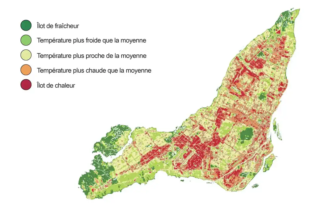
Sur la carte des îlots de chaleur de Montréal de 2019, une tache rouge bordée d’orange apparaît au centre du parc Rutherford, situé sur le flanc du mont Royal. Pourtant, six années auparavant, la zone apparaissait en vert sur la carte produite à partir d’images satellite. C’est qu’entre les deux prises d’images, un terrain sportif ...
ledevoir.com
NuView Aims To Map Earth In 3D Using Satellite Based LiDAR

NuView Aims To Map Earth In 3D Using Satellite Based LiDAR

Terrestrial LiDAR (Light Detection and Ranging) for 3D imaging has matured tremendously in the last decade, thanks to consumer (mobile phones and computers) and automotive safety and autonomy applications. Over 70 companies are vying for a portion of this $billion market. In the meantime, the technology has progressed for drone and higher altitude aerial 3D ...
forbes.com
Secondary Forests More Sensitive To Drought Than Primary Forests

Secondary Forests More Sensitive To Drought Than Primary Forests

Northern boreal forest ecosystems are predicted to experience more frequent summer droughts in the future. The majority of Swedish forest are secondary forests that are managed commercial forests with little diversity in species and structure. Only a small part is made up of primary forests that have experienced limited direct human impact. So far, it ...
sciencedaily.com