Geomaticians

15

Brasileiros Criam Satélite Para Prever Interferências Em Sinal De Geolocalização

Cientistas brasileiros estão entre os encarregados de uma missão espacial para estudar anomalias que bloqueiam sinais de satélite. Com o lançamento do Sport no final deste mês, será possível entender, com maior precisão, como essas ocorrências afetam a infraestrutura de comunicação. Sigla para Tarefa de Pesquisa, Observação e Previsão de Cintilação, o Sport resultou da ...
acessa.com
Amazonas Ganha Plataforma Georreferenciada Com Mapas E Dados Sobre Educação E Trabalho

Amazonas Ganha Plataforma Georreferenciada Com Mapas E Dados Sobre Educação E Trabalho

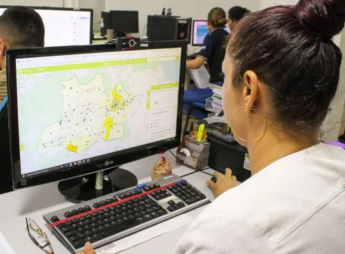
O Amazonas passa a contar, pela primeira vez, com o Geoportal Amazonas em Mapas, uma plataforma on-line georreferenciada com dados públicos em formato de mapas que serão úteis para a formulação de políticas públicas no estado. A ferramenta faz parte da parceria entre o Governo do Amazonas, por meio da Secretaria de Desenvolvimento Econômico, Ciência, ...
agenciaamazonas.am.gov.br
Pampa Sul-americano Perde Um Quinto Da Vegetação Campestre Entre 1985 E 2021

Pampa Sul-americano Perde Um Quinto Da Vegetação Campestre Entre 1985 E 2021

A análise de imagens de satélite captadas entre 1985 e 2021 por uma rede colaborativa de especialistas da Argentina, Brasil e Uruguai, sob coordenação do MapBiomas, mostra que o Pampa Sul-Americano perdeu 20% de sua vegetação campestre no período, incluindo 8,7 milhões de hectares de campos nativos e 260 mil hectares de florestas. Os dados ...
extraclasse.org.br
Con Datos Geoespaciales Cuantifican El Estado De Los Suelos Degradados En Chile

Con Datos Geoespaciales Cuantifican El Estado De Los Suelos Degradados En Chile

El Ministerio de Agricultura impulsó en 2010 el ‘Sistema de Incentivos para la Recuperación de Suelos Degradados (SIRSD-S)’, un instrumento que busca rescatar el potencial productivo de los suelos agropecuarios en degradación. La iniciativa es coordinada por la Subsecretaría de Agricultura y ejecutada por el Servicio Agrícola y Ganadero (SAG), en conjunto con el Instituto ...
mundoagro.cl
AgEagle Introduces The New eBee VISION Intelligence, Surveillance And Reconnaissance Drone

AgEagle Introduces The New eBee VISION Intelligence, Surveillance And Reconnaissance Drone

AgEagle Aerial Systems Inc. , an industry-leading provider of full stack flight hardware, sensors and software for commercial and government/defense use, today announced its introduction of the new eBee™ VISION, a small, fixed-wing unmanned aerial system (“UAS”) designed to provide real-time, enhanced situational awareness for critical Intelligence, Surveillance and Reconnaissance (“ISR”) missions. Scheduled for global ...
uasweekly.com
Airbus Foundation Looks To Put Satellites To New Biodiversity Conservation Uses

Airbus Foundation Looks To Put Satellites To New Biodiversity Conservation Uses

The Airbus Foundation and the Connected Conservation Foundation (CCF) recently announced a new award for research that would use satellites to aid in biodiversity conservation. The application period, open to individual researchers and nonprofit organizations, began Dec. 5 and ends Feb. 3, 2023. A team of four judges will assess the potential of proposals designed ...
news.mongabay.com

High Tech Snow Flights To Cover Most Of California’s Watersheds This Year

You probably didn’t notice a twin-engine prop plane loaded with high-tech equipment circling 23,000 feet over the San Joaquin Valley’s upper watersheds this fall. But it was there, gathering information about those watersheds in their “snow off” condition. That detailed information will be vital to multiple follow up flights of Airborne Snow Observatories, Inc. (ASO) ...
kvpr.org

Iran, Russia Sign Deal To Develop Space Cooperation

The agreement was signed by the head of Iran’s Space Agency Hassan Salarieh and the chief of Russia’s space agency, Roscosmos Yury Borisov on the sidelines of an International Aerospace Exhibition in Kish Island in southern Iran in the Persian Gulf. This cooperation document includes a variety of topics, including cooperation in the construction of ...
en.mehrnews.com
Unveiling Italy’s Hidden History With Fixed-wing Mapping UAVs

Unveiling Italy’s Hidden History With Fixed-wing Mapping UAVs

Mapping an archaeological site is key to being able to dig with greater precision. Now with the latest digital methods, areas of interest can easily be identified rapidly and non-invasively – helping to protect the site and future excavations. Here, Chris Thompson, Global Sales Manager at AgEagle, looks at how a team of Duke University ...
gim-international.com