Geomaticians

Tool | Resource

3D-Modell Und Sensoren - Memmingen Digital

3D-Modell Und Sensoren – Memmingen Digital

Wieviele Fußgänger sind in Memmingen gerade in der Kramerstraße unterwegs? Wie ist die aktuelle Temperatur am Weinmarkt? Wie voll sind die Wertstoffcontainer am Westertor? Das alles messen neu installierte Sensoren – und ihr könnt diese Infos einfach online über den Digitalen Zwilling der Stadt Memmingen per Maus-Klick abrufen. Das Projekt ist jetzt auch dem Memminger ...
imsueden.de
Trees Are Moving North From Global Warming. Look Up How Your City Could Change.

Trees Are Moving North From Global Warming. Look Up How Your City Could Change.

As greenhouse gas emissions nudge temperatures higher, trees’ growing ranges are shifting northward, projections from the U.S. Forest Service show. Trees near the southern edge of their geographic ranges — what scientists refer to as “plant hardiness zones” — will be left behind, while northern latitudes will welcome new species from the south. Plant hardiness ...
washingtonpost.com
OpenAI’s Shap-E Model Makes 3D Objects From Text Or Images

OpenAI’s Shap-E Model Makes 3D Objects From Text Or Images

Recently, we’ve seen AI models that produce detailed text-to-video or use run a chatbot on your phone. Now, OpenAI, the company behind ChatGPT, has introduced Shap-E, a model that generates 3D objects you can open in Microsoft Paint 3D or even convert into an STL file you can output on one of the best 3D ...
tomshardware.com
European Environment And Health Atlas Goes Live

European Environment And Health Atlas Goes Live

The interactive online tool, a first on such a scale for all of Europe, allows users to visualise how the environment around them affects their health and well-being via set of detailed maps. It covers topics like air quality, noise and quietness, green and blue spaces and climate change throughout the member and collaborating countries ...
Overture Maps Foundation Releases Preliminary Map Dataset

Overture Maps Foundation Releases Preliminary Map Dataset

The Overture Maps Foundation, a community-driven effort to develop an open map dataset built for map service providers, last month announced the first public showing of their work in what they are referring to as a “pre-release.” The Overture Maps Foundation was officially formed last December in an effort headed by the Linux Foundation with ...
geoweeknews.com
El Primer Mapa De Riesgos Climáticos En Canarias Detalla Qué Municipios Sufrirán Más Los Efectos Del Calentamiento Global

El Primer Mapa De Riesgos Climáticos En Canarias Detalla Qué Municipios Sufrirán Más Los Efectos Del Calentamiento Global

El impacto de la crisis climática no será igual en toda Canarias. Nuevos datos difundidos por el Gobierno regional revelan que municipios como Pájara, en Fuerteventura, o Haría, en Lanzarote, sufrirán más los efectos del calentamiento global en sus costas que otras regiones del Archipiélago. Los resultados concluyen, de nuevo, que la dependencia del turismo ...
eldiario.es
Track, Trace And Triumph How Utah Division Of Wildlife Resources And Google Public Sector Are Setting The Standard To Protect The State’s Wildlife

Track, Trace And Triumph: How Utah Division Of Wildlife Resources And Google Public Sector Are Setting The Standard To Protect The State’s Wildlife

Fast forward to 2023, and now Utah DWR officials can get real-time location data for thousands of animals without leaving their office. What’s more, they can overlay today’s location data with up to 20 years of historical information to make data-driven decisions to improve wildlife habitat and populations using the state’s Wildlife Tracker application, running ...
utahbusiness.com
Geographic Technology Provides Landowners With Precise Tools When Making Land Management Decisions

Geographic Technology Provides Landowners With Precise Tools When Making Land Management Decisions

According to Lee Burras and Bradley Miller, agronomists at Iowa State University, advances in geospatial technology coupled with more traditional farming knowledge have allowed researchers and landowners to understand the land more intimately than ever before. Miller, who began his career working in water quality, has seen firsthand how soil can be impacted by the ...
extension.iastate.edu
NOAA Making Vessel Traffic Data More Accessible To Public

NOAA Making Vessel Traffic Data More Accessible To Public

The Automatic Identification System that tracks vessel movements with transponders on ships has helped create an “AIS database of 30 billion-plus vessel locations has become the go-to resource for maritime planners and ocean geospatial tech experts,” according to a recent summary from NOAA. That data is a base for a NOAA website, MarineCadastre.gov . For ...
workboat.com
Córdoba Actualizó Los Mapas Digitales De Propiedades De Suelo

Córdoba Actualizó Los Mapas Digitales De Propiedades De Suelo

A través de un trabajo interinstitucional, la provincia de Córdoba actualizó los mapas digitales, a escala semi-predial, de materia orgánica (MO), fósforo (P) y Ph. Estas actividades forman parte de la estrategia de Mapeo Digital de Suelos (MDS), en una labor colaborativa iniciada hace más de 3 años entre el Ministerio de Agricultura y Ganadería, ...
agroverdad.com.ar

State Unveils Interactive Soil, Water Sampling Map

The Pennsylvania Department of Environmental Protection (DEP) on Tuesday released a new interactive mapping tool that shows final sample results from soil and water testing conducted by DEP in the wake of the Feb. 3 East Palestine train derailment. Pennsylvanians can use this tool to review sampling results in the vicinity of the derailment. The ...
latrobebulletinnews.com
Carbon Brief Interactive Map

Carbon Brief Interactive Map

Carbon Brief reveals visually just how much the world’s most populous regions have been affected by extreme heat since 2013.
interactive.carbonbrief.org
St. Cloud Launches Interactive Road Closure Map

St. Cloud Launches Interactive Road Closure Map

St. Cloud has a live interactive map to help people navigate the city’s road closures. The online information includes long-term road projects, short-term closures for repairs or emergencies, and event-related road closures. The map is updated with every closure that occurs. Just click on the highlighted road segment, and a pop-up window will appear with ...
knsiradio.com
Visor Geográfico Del Espacio Público, Nueva 'App' Para Movilizarse Por Bogotá

Visor Geográfico Del Espacio Público, Nueva ‘App’ Para Movilizarse Por Bogotá

Si en su barrio cerraron un predio que siempre estuvo abierto a la ciudadanía o le interesa conocer cuáles son las rutas de ciclorruta que pasan por su localidad, desde ya tiene una herramienta a la mano que le permitirá hacerlo fácil, rápido, sin intermediarios y a cualquier hora del día gracias al Visor Geográfico ...
eltiempo.com
Dados Sobre O Relevo De Minas São Disponibilizados Pelo Ide-sisema

Dados Sobre O Relevo De Minas São Disponibilizados Pelo Ide-sisema

Informações sobre o relevo de Minas Gerais estão disponíveis na plataforma de dados espaciais do Sistema Estadual de Meio Ambiente e Recursos Hídricos (IDE-Sisema), para pesquisas dos cidadãos sobre as características físicas do território mineiro, além de subsidiar as análises ambientais feitas pelo Governo de Minas. A novidade, publicada na plataforma na última semana, passa ...
agenciaminas.mg.gov.br
Litto3d, Un Outil Gratuit Du SHOM Pour Découvrir Les Reliefs Maritimes

Litto3d, Un Outil Gratuit Du SHOM Pour Découvrir Les Reliefs Maritimes

Litto3D est un outil cartographique mis à disposition par le SHOM en accès gratuit. Ce produit propose une cartographie de l’altimétrie littorale, que ce soit à terre ou en mer pour une grande partie des côtes françaises. Avec Litto3D, on se promène sur la carte en découvrant à la fois les reliefs terrestres et les ...
bateaux.com
Heigit Disaster Portal Erfolgreich Nach Erdbeben In Der Türkei Und In Syrien Eingesetzt

Heigit Disaster Portal Erfolgreich Nach Erdbeben In Der Türkei Und In Syrien Eingesetzt

Das Heidelberg Institute for Geoinformation Technology (HeiGIT) hat im Februar 2023 mit Input des GIS-Team Nahost der Médecins Sans Frontières (Ärzte ohne Grenzen/MSF) sein Disaster Portal für die betroffene Region eingerichtet. Das Portal ist ein wichtiges Werkzeug für Hilfsorganisationen wie MSF und hilft mit seinen Echtzeitinformationen, die Einsätze der Helfer:innen vor Ort effizient zu planen. ...
idw-online.de

El Mapa De Recetas Fitosanitarias De Córdoba Creció Más De 500 Mil Hectáreas

El mapa de Recetas Fitosanitarias Digital (RFD) es una herramienta que permite la trazabilidad del sistema de recomendación y uso de fitosanitarios agrícolas en la provincia a nivel de una parcela o área geográfica particular. El RFD, desarrollado por la Dirección General de Fiscalización y Control de Córdoba, con el apoyo de IDECOR, muestra un ...
revistachacra.com.ar
Afet Sağlık Haritası Hizmete Girdi

Afet Sağlık Haritası Hizmete Girdi

MEDAK, Kahramanmaraş merkezli depremlerin etkilediği illerde sağlık kuruluşları hakkında sahadaki insanların doğru ve güncel olarak bilgilendirilmesi için çalışma başlattı. Bu kapsamda dernek, deprem bölgesinde görev alan tüm yabancılar da dahil resmi ve özel yardım yardım kuruluşlarıyla temasa geçerek, gerek kendi görevlileri gerekse diğer kurumların yetkili kişileri tarafından illerde hizmet veren sabit veya gezici tüm sağlık ...
yenicaggazetesi.com.tr
Interactive Map Of Spring Hummingbird Migration Every State They'll Arrive In Plus Feeding Tips

Interactive Map Of Spring Hummingbird Migration: Every State They’ll Arrive In Plus Feeding Tips

Spring has arrived in the United States and hummingbirds are headed north. The birds typically migrate north in the late winter and spring, after spending their winters in parts of Central America or Mexico. An online map gives you a close look at the birds’ route north and when to expect their arrival as they ...
usatoday.com
Este Mapa Interactivo Mostra-te A “Cidade De 15 Minutos” Que Existe Em Lisboa

Este Mapa Interactivo Mostra-te A “Cidade De 15 Minutos” Que Existe Em Lisboa

Uma pequena ferramenta desenvolvida no contexto do último Conselho de Cidadãos, dedicado à “cidade dos 15 minutos”, permite a qualquer pessoa perceber o que tem próximo da sua residência, local de trabalho ou no seu bairro. O mapa foi desenvolvido por Manuel Banza, cientista de dados e entusiasta de cidades, para ajudar os participantes a ...
lisboaparapessoas.pt
Seattle City Of Literature Debuts Map With Dozens Of South Ends Spots And Literary Heroes

Seattle City Of Literature Debuts Map With Dozens Of South Ends Spots And Literary Heroes

Last month Seattle City of Literature launched the Seattle Literary Map in print and digitally. The Literary Map is a guide to the people, places, businesses, and organizations that have made important contributions to Seattle’s literary scene. Seattle is one of only two UNESCO Cities of Literature in the United States. The Literary Map honors ...
‘A Network Of Belonging’ Meet The Woman Mapping Out The ’60s Scoop

‘A Network Of Belonging’: Meet The Woman Mapping Out The ’60s Scoop

Until she was in college, Colleen Cardinal thought she and her sisters were the only Indigenous people taken from their families at birth and adopted by a white family. Since learning she isn’t alone, Cardinal wants to make sure her story, and the stories of thousands of others, are heard. “I wanted to find all ...

Web App Soon For Easy Access To BBS Data

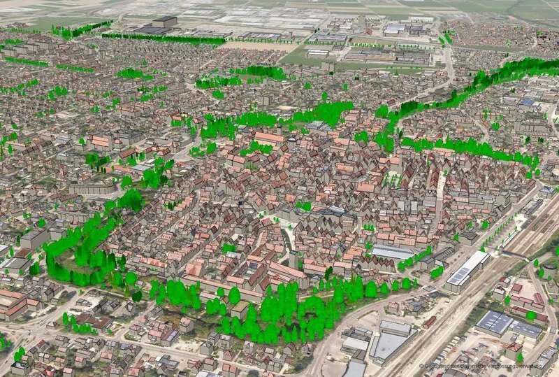
The national statistical bureau is going to introduce a web application for supplying statistics based on GIS, aimed at ensuring easy access to data for all. The Bangladesh Bureau of Statistics (BBS) with the technical support of the Centre for Environmental and Geographic Information Services (CEGIS) is developing the app, BBS joint director Md Rafiqul ...
thefinancialexpress.com.bd

Satélite Miranda Ofrece Más De 600 Mil Imágenes Para Investigación

El satélite Miranda pone a disposición del público más de 600 mil imágenes capturadas durante su década en el espacio ultraterrestre, como aporte a la investigación y educación, y parte de la iniciativa denominada Ciencia Abierta. De acuerdo con una nota de la Agencia Bolivariana para Actividades Espaciales (ABAE), ente adscrito al Ministerio para Ciencia ...
ultimasnoticias.com.ve
Sistema Georreferenciado Para Emergencias Rurales Del Partido De Olavarría

Sistema Georreferenciado Para Emergencias Rurales Del Partido De Olavarría

En un trabajo en conjunto entre la Dirección de Desarrollo Agropecuario y GIS de la Dirección de Gobierno Digital, ambas dependientes de la Secretaría de Desarrollo Económico del Municipio, se desarrolló SIGE: un sistema que ubica cada tranquera existente de establecimientos rurales del partido, que asimismo incluye una serie de herramientas para que, de manera ...
olavarria.gov.ar