Geomaticians

Tool | Resource

El Mapa Con El Que Puedes Escuchar El Sonido De Todos Los Bosques Del Mundo

Sounds of the Forest ha creado un mapa (que puedes encontrar pinchando aquí) con bosques de todo el mundo con sonidos ambiente en el que se puede oír de todo, desde las hojas de los árboles hasta animales de todo el planeta, como los lémures de Madagascar o al ruiseñor de Eslovaquia. Es decir, se ...
lasexta.com

Study Finds Neighborhood Features Impact Mental And Physical Health For Better Or Worse

Sidewalks, single-lane roads and street signs could all be part of the path to a community’s mental and physical health, for better or worse, according to a new University of Maryland-led study. The research analyzed Google Street View images of diverse regions of the United States to correlate elements of the built environment to health ...
today.umd.edu

Online ‘Warm Spaces’ Map To Help Residents In Leeds Goes Live

An online map showing the locations of ‘warm spaces’ in Leeds to help people with the cost of living crisis has gone live today. The map, which can be seen at Warm Spaces Public app – embed (arcgis.com), shows the venues across the city which people are able to visit to keep warm to reduce ...
news.leeds.gov.uk

Interactive Map Shows Where Metro Thinks Multimodal Improvements Should Be Built

The map of Metro’s Draft Prioritized Active Transportation Network was revealed last week during community stakeholder briefings. In its default view, it shows where bikeways, pedestrian districts, and first-last-mile station improvements are prioritized by the agency. SBLA is calling this the Default Map here, and it’s the cover image above. But the interactive map allows ...
la.streetsblog.org

Geoportale E-mapa.Net Otworzą Więcej Typów Geodanych

Dotychczas portale te pozwalały wizualizować w oknie mapy dane rastrowe w formacie GeoTiFF oraz wektorowe w formatach: AutoCAD (DXF), GML, GPX, Google Earth (KML/KMZ) oraz Shapefile (SHP). Po aktualizacji lista obsługiwanych plików wektorowych poszerzyła się o: GeoJSON (GEOJSON, JSON), GeoPackage (GPKG), GPX, MapInfo (MIF) oraz SQLite/SpatiaLite (SQLITE). Nowością jest też łatwiejsze otwieranie plików w wyżej ...
geoforum.pl
New Interactive Map Showcases Buildings And Places That Shaped The BBC

New Interactive Map Showcases Buildings And Places That Shaped The BBC

From the inspiration for Dr Who’s TARDIS to the filming location for CBBC’s Balamory, the people, places and buildings that have defined the BBC have been highlighted as part of a new digital map available this autumn. Today (13 October), Historic England, Historic Environment Scotland (HES), Historic Environment Division, Northern Ireland Communities Department and Cadw, ...
historicenvironment.scot

Matriz De Bienestar Humano Territorial: Una Herramienta Para Mejorar La Calidad De Vida

Para colaborar en una descentralización exitosa y fortalecer a los gobiernos regionales, nace la Matriz de Bienestar Humano Territorial (MBHT), diseñada por el Centro de Inteligencia Territorial del Design Lab de la Universidad Adolfo Ibáñez (CIT.UAI.CL), en el marco del “Programa Nacional de Fortalecimiento de Capacidades Regionales” que lleva a cabo la Subsecretaría de Desarrollo ...
archdaily.mx

New Mapping Techniques Rapidly Identified Hurricane Damage Across All Of Florida. Here’s How They Work

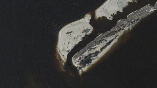
Hurricane Ian left an extraordinarily broad path of destruction across much of South Florida. That was evident in reports from the ground, but it also shows up in satellite data. Using a new method, our team of spatial and environmental analysts was able to quickly provide a rare big picture view of damage across the ...
fastcompany.com

Man Creates Mapping Tool To Help Locals Find Boston’s Best Dive Bars

If you’re looking for a place “where everyone knows your name”, a new mapping tool could help you find it. A lot of swanky bars and restaurants with plush lounges and expensive cocktails have opened around Boston. One local man prefers a reasonably priced draft and some home style cooking. He’s on a quest to ...
boston25news.com
Mcdonald's 'Mcbroken' Map Reveals Where Ice Cream Machines Are Broken In The UK

Mcdonald’s ‘Mcbroken’ Map Reveals Where Ice Cream Machines Are Broken In The UK

McDonald’s is the nation’s favourite fast food restaurant, enjoyed by Brits young and old with Big Macs, Quarter Pounders and of course, the chicken nuggets, firm favourites when in the mood for a quick bite. But there is one thing that gripes us all, the regularity of broken ice cream machines. There is nothing worse ...
thewestmorlandgazette.co.uk
Zaawansowane Analizy Geostatystyczne Na Wyciągnięcie Ręki

Zaawansowane Analizy Geostatystyczne Na Wyciągnięcie Ręki

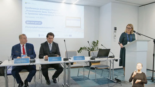
Nie chcemy tylko i wyłącznie koncentrować się na metodyce prowadzenia badań statystycznych i generowaniu z nich wyników. Pragniemy, by te wyniki nie leżały odłogiem, a były wykorzystywane przez naszych użytkowników – kontynuował prezes GUS. I w tym właśnie ma pomóc nowa rozbudowana wersja Portalu Geostatystycznego powstała w ramach podsumowanego projektu. – Efektem prac jest stworzenie ...
geoforum.pl

USAR Damage Assessment Map Gives Information And A Look At Properties On Sanibel Island

A map that shows damage levels to properties on Sanibel Island has been completed from the assessment of structures by Urban Search and Rescue Teams. The damage assessments show there is widespread damage on the island, causing dangerous conditions throughout Sanibel and particularly in and around various structures. Maps can be viewed by clicking here ...
news.wgcu.org

Mapa Powie, Czy Warto Inwestować W Pompę Ciepła

To, że technologie GIS-owe wspierają wykorzystanie alternatywnych źródeł energii, nie jest niczym nowym. W ostatnich latach powszechne stały się bowiem różnorodne lokalne serwisy mapowe prezentujące potencjał solarny budynków. Dzięki nim właściciel nieruchomości może łatwo sprawdzić, czy opłaca mu się instalować panele fotowoltaiczne, a bardziej szczegółowe serwisy wskazują nawet konkretne fragmenty dachu najlepiej nadające się do ...
geoforum.pl

New Aerial Imagery Available For Crow Wing County Residents

Higher-resolution aerial imagery captured this spring for Crow Wing County is now available to residents. The imagery, captured through a flight by EagleView Pictometry , has a 2-inch resolution compared to the previous 6-inch resolution. “You will see when viewing at the street level or closer, the amount of detail visible compared to past aerial ...
brainerddispatch.com
September 2022 Hurricane Ian

September 2022: Hurricane Ian

On September 29, the National Geodetic Survey (NGS) began collecting aerial damage assessment images in the aftermath of Hurricane Ian. Imagery is being collected in specific areas by NOAA aircraft, identified by NOAA in coordination with FEMA and other state and federal partners. Collected images are available to view online via the NGS aerial imagery ...
oceanservice.noaa.gov
Climap Una Mappa Partecipata Degli Eventi Climatici Estremi

Climap: Una Mappa Partecipata Degli Eventi Climatici Estremi

Una mappatura partecipata di tutti gli eventi meteo estremi che colpiscono il nostro Paese. Questo l’obiettivo di CLIMap, progetto di gisAction e Legambiente che vuole accendere i riflettori sul rischio climatico e sulla crisi climatica a partire dall’esperienza del singolo cittadino. Ogni utente potrà quindi segnalare l’evento climatico estremo che lo ha colpito e quali ...
ilgiornaledellaprotezionecivile.it

Open Access To Tasmania’s Historic Aerial Imagery

Land Tasmania has released a new version of its Aerial Photo Viewer (APV), which enables people to search, view and download free of charge, images from the extensive aerial record of Tasmania managed by the agency. The images span the period from 1945 to the present, and both historic and newly captured imagery is continually ...
spatialsource.com.au

Eine Hochauflösende, Verzerrungsfreie Und Massstabsgetreue Abbildung Der Kantonsoberfläche

Der Kanton Zug verfügt wieder über ein aktuelles Orthofoto. Es ist passgenau zu den bereits vorhandenen Geodaten und damit auch zum Plan für das Grundbuch. Das letzte flächendeckende Orthofoto des Kantons Zug stammt laut Medienmitteilung aus dem Jahre 2011. Zwischenzeitlich wurden Aufnahmen jeweils nur für kleinere Gebiete erstellt. Ein Orthofoto ist eine verzerrungsfreie und massstabsgetreue ...
bote.ch
New Mapping Tool To Support The Search For High-quality Nature-based Carbon Credits

New Mapping Tool To Support The Search For High-quality Nature-based Carbon Credits

An interactive mapping software that will support the prospecting, development and management of nature-based carbon credit projects worldwide was launched on 22 September at the World Economic Forum – Champions for Nature event in New York during Climate Week NYC 2022. The open-access platform (http://carbonprospecting.org), dubbed the Carbon Prospecting Dashboard, was jointly developed by the ...
newswise.com
Researchers Map Streamflow Alterations To Gauge Human Impact On Ecosystems

Researchers Map Streamflow Alterations To Gauge Human Impact On Ecosystems

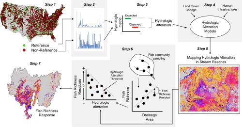
Altering streamflow can endanger the ecosystems that rely on it, but researchers have lacked data on how human infrastructure has impacted streamflow in the U.S. Now, a study involving a Colorado State University researcher has mapped streamflow alterations across the continental U.S., providing a wealth of data for determining societal impacts on ecosystems. Up to ...
phys.org