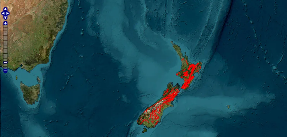
Geomaticians

Dataset

NASA Releases New High-Quality, Near Real-Time Air Quality Data

NASA Releases New High-Quality, Near Real-Time Air Quality Data

NASA has made new data available that can provide air pollution observations at unprecedented resolutions – down to the scale of individual neighborhoods. The near real-time data comes from the agency’s TEMPO (Tropospheric Emissions: Monitoring of Pollution) instrument, which launched last year to improve life on Earth by revolutionizing the way scientists observe air quality ...
nasa.gov

Organic Farms Can Have Mixed Effects On Pesticide Use Depending On Their Neighbors

Organic agriculture may be as old as dirt, but that doesn’t mean its impacts are fully understood. A team of scientists in the United States and Canada are doing their part to change that. Researchers at UC Santa Barbara, University of British Columbia, and University of Colorado Boulder discovered that organic farming significantly affects the ...
news.ucsb.edu
Online Map For Ground Mounted Solar Plants In China

Online Map For Ground Mounted Solar Plants In China

Scientists led by the China Agricultural University have created a national-scale map and dataset of ground-mounted PV power stations in China. The data is based on Sentinel-2 imagery from 2020 and has a spatial resolution of 10 meters. According to the researchers, the publicly available data set can assist capacity estimation and prediction tasks, site ...
pv-magazine.com
New 'Digital Twin' Earth Technology Could Help Predict Water-Based Natural Disasters Before They Strike

New ‘Digital Twin’ Earth Technology Could Help Predict Water-Based Natural Disasters Before They Strike

The water cycle looks simple in theory—but human impacts, climate change, and complicated geography mean that in practice, floods and droughts remain hard to predict. To model water on Earth, you need incredibly high-resolution data across an immense expanse, and you need modeling sophisticated enough to account for everything from snowcaps on mountains to soil ...
phys.org
Online Mapping Tool Offers Land Use Information

Online Mapping Tool Offers Land Use Information

A new online tool allows users to examine agricultural land use across the country. Developed by ALCES for the Canadian Agri-Food Policy Institute, the Agriculture Web Mapping Application Tool offers maps and datasets about land use, management practices and agri-environmental indicators. Census, crop production and land use data can be viewed individually or overlaid. Tyler ...
producer.com
GUGIK Udostępnił Dane Ukośne I Modele 3D Mesh Dla Malborka

GUGIK Udostępnił Dane Ukośne I Modele 3D Mesh Dla Malborka

Do Państwowego Zasobu Geodezyjnego i Kartograficznego przyjęto kolejne wysokorozdzielcze dane fotogrametryczne dla miasta Malbork, opracowane na zlecenie Głównego Geodety Kraju. Dane obejmują: Zdjęcia lotnicze pionowe i ukośne o GSD = 5cm; Ortofotomapę klasyczną i ukośną o terenowym rozmiarze piksela 5 cm; Chmurę punktów o gęstości co najmniej 12 pkt/m2 (PL-EVRF2007-NH); Numeryczny model terenu (NMT) o ...
gisplay.pl
New Map Shows Where Damaging Earthquakes Are Most Likely To Occur In US 

New Map Shows Where Damaging Earthquakes Are Most Likely To Occur In US 

Nearly 75% of the U.S. could experience damaging earthquake shaking, according to a recent U.S. Geological Survey-led team of more than 50 scientists and engineers. This was one of several key findings from the latest USGS National Seismic Hazard Model (NSHM). The model was used to create a color-coded map that pinpoints where damaging earthquakes ...
phys.org

Cartografia E Telerilevamento, Online L’aggiornamento Dei Dati Territoriali

Si aggiorna e si sviluppa il patrimonio foto-cartografico della Toscana. Sono disponibili online nuovi prodotti derivati dai più recenti rilievi aerei che consentiranno una conoscenza ancora più approfondita di tutto il territorio regionale e delle sue trasformazioni. Questo grazie a specifici progetti di telerilevamento realizzati con risorse interamente regionali. Si tratta, nello specifico, di aggiornamenti ...
toscana-notizie.it
This Website Will Help You Find The Best Driving Roads In The World

This Website Will Help You Find The Best Driving Roads In The World

The search for the perfect driving road never ends. Besides being a subjective matter, how does one even begin such a monumental task as seeking out roads around the world? Actually, it may not be as daunting as you think, thanks to this very cool website that not only highlights twisty roads, but delivers gobs ...
motor1.com

MapBiomas Publica Coleção De Mapas Com 10 Metros De Resolução Espacial

O MapBiomas publicou sua primeira coleção de mapas anuais de cobertura e uso da terra do Brasil feita a partir de imagens de satélite com resolução espacial de 10 metros. A coleção MapBiomas 10 Metros beta produzida com dados dos satélites Sentinel-2 traz os anos de 2016 a 2022 e utiliza um método semelhante e ...
mundogeo.com
Australia, Canada And US Unify Critical Minerals Data

Australia, Canada And US Unify Critical Minerals Data

The U.S. Geological Survey (USGS) has released a compilation of national-scale geological, geophysical and mineral resource datasets from Australia, Canada and the US through a collaboration between the three countries’ federal geological surveys. “Geology doesn’t stop at the border and neither does our data,” said USGS scientist Anne McCafferty, who led the effort. “Scientists will ...
usgs.gov

Índice De Clasificaciones De Agua Superficial Desde El Espacio Landsat 2022

El Instituto Nacional De Estadística Y Geografía (INEGI) Pone A Disposición De Las Y Los Usuarios El Índice De Clasificaciones De Agua Superficial Desde El Espacio (ICASE) Landsat 2022. Este Consiste En Un Producto De Análisis Geoespacial Experimental Que Proporciona Información Sobre La Presencia De Agua Superficial A Lo Largo De Todo El Territorio Mexicano. ...
journalmex.com.mx
Meta, Microsoft And Amazon Release Open Map Dataset To Rival Google Maps, Apple Maps

Meta, Microsoft And Amazon Release Open Map Dataset To Rival Google Maps, Apple Maps

A group formed by Meta, Microsoft, Amazon and mapping company TomTom is releasing data that could enable developers to build their own maps to take on Google Map and Apple Maps. The group, called the Overture Maps Foundation, was formed last year. Today, the group has released it first open map dataset. With this dataset, ...
techcrunch.com

USDA Introduces Geospatial Data Product To Show Crop Rotation Patterns

The U.S. Department of Agriculture unveiled a geospatial product called Crop Sequence Boundaries (CSB) that offers public access to national-scale visual crop rotation data for the first time. The new tool was developed by USDA’s National Agricultural Statistics Service (NASS) and Economic Research Service (ERS), two of the department’s statistical scientific research agencies. CSB is ...
nass.usda.gov

Wyoming Natural Diversity Database Debuts New Online Tool At UW

The Wyoming Natural Diversity Database (WYNDD) at the University of Wyoming will replace two of its most popular online data access tools with a new online tool. The WYNDD Data Explorer will combine and streamline the functionality of the two former tools. “This new web application allows users to view and download spatial data related ...
uwyo.edu
NETL CO2-locate Database To Enhance Carbon Capture And Storage Projects

NETL CO2-locate Database To Enhance Carbon Capture And Storage Projects

Creating a net-zero carbon emissions power sector and economy is an immense endeavor that requires a host of intricate technologies and applications, and the CO2-Locate database is a centralized platform that allows users to quickly and accurately obtain the data they need. Now published on the Energy Data eXchange® (EDX), CO2-Locate is one of several ...
netl.doe.gov
Overture Maps Foundation Releases Preliminary Map Dataset

Overture Maps Foundation Releases Preliminary Map Dataset

The Overture Maps Foundation, a community-driven effort to develop an open map dataset built for map service providers, last month announced the first public showing of their work in what they are referring to as a “pre-release.” The Overture Maps Foundation was officially formed last December in an effort headed by the Linux Foundation with ...
geoweeknews.com

Satélite Miranda Ofrece Más De 600 Mil Imágenes Para Investigación

El satélite Miranda pone a disposición del público más de 600 mil imágenes capturadas durante su década en el espacio ultraterrestre, como aporte a la investigación y educación, y parte de la iniciativa denominada Ciencia Abierta. De acuerdo con una nota de la Agencia Bolivariana para Actividades Espaciales (ABAE), ente adscrito al Ministerio para Ciencia ...
ultimasnoticias.com.ve