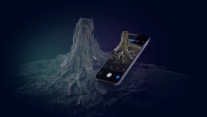
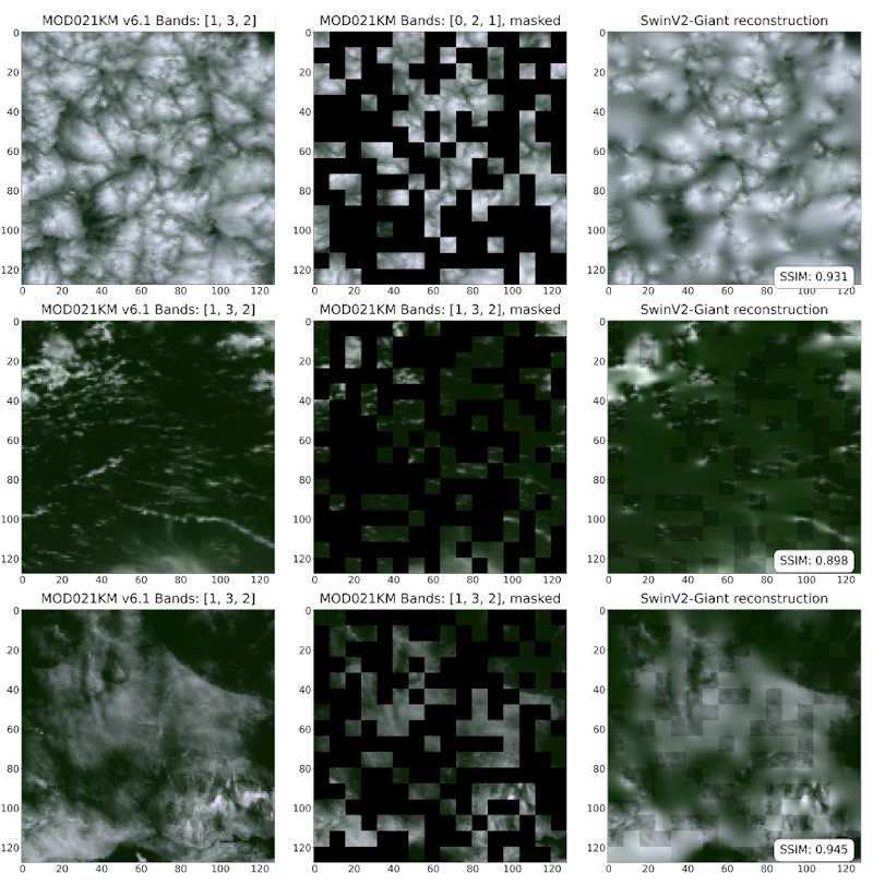
Geomaticians

Application

Biodiversity Survey Tool For Meeting New Net Gain Obligations

Biodiversity Survey Tool For Meeting New Net Gain Obligations

Esri UK partner Temple has created a biodiversity assessment tool, which could assist construction and engineering firms in meeting the biodiversity net gain (BNG) legislation that came into effect in England earlier this year. Environment, planning and sustainability consultancy Temple has joined geographic information system (GIS) software provider Esri UK’s partner network. This allows Temple ...
geplus.co.uk
Ant Group Launches Multimodal Remote Sensing Model “SkySense”

Ant Group Launches Multimodal Remote Sensing Model “SkySense”

According to the Chinese media outlet Sina Tech, Ant Group has launched a 2 billion parameter multimodal remote sensing base model called SkySense. This is the latest research achievement of Ant’s Bailing large model in the multimodal field, and its paper has been accepted by the top computer vision conference CVPR 2024. SkySense can be ...
pandaily.com
Cartographie Des Traditions Orales Terrastories Arrive Sur Le Maroni

Cartographie Des Traditions Orales : Terrastories Arrive Sur Le Maroni

Déjà testée et approuvée au Suriname, l’application Terrastories est désormais en train d’être introduite sur le Haut-Maroni et Papaïchton, afin que les communautés Wayana et Aluku puissent cartographier leurs traditions orales sur des lieux qui ont une signification ou une valeur importante pour elles. Terrastories est une application mobile permettant aux communautés de cartographier, protéger ...
franceguyane.fr

IMD Launches Weather Forecast Portal For Farmers & MAUSAM App

New Delhi, Jan 15 (UNI) India Meteorological Department (IMD) on the 150th year of its establishment, on Monday launched the weather forecast portal ‘Panchayat Mausam Seva for farmers’ to support farmers with timely weather alerts and warnings for planning agricultural activities accordingly. “Through this portal, weather forecasts in English, Hindi and twelve regional languages will ...
uniindia.com

New GISTDA App Warns Of Hot Spots To Reduce Wildfire Risks

The GISTDA is continuing to develop its application called FAIPA, “Forest Fire” in English, to notify hotspots at the sub-district, district, and provincial levels, using real-time or near real-time satellite data for primary users, including agencies like the Department of Disaster Prevention and Mitigation, volunteer groups, and local residents. The application provides nationwide hotspot data, ...
nationthailand.com
Près De 60 % Des Bâtiments Cartographiés Dans Le Cadre De La Plus Grande Recherche Canadienne Sur L'accessibilité Ne Sont Pas Accessibles

Près De 60 % Des Bâtiments Cartographiés Dans Le Cadre De La Plus Grande Recherche Canadienne Sur L’accessibilité Ne Sont Pas Accessibles

Une nouvelle recherche publiée aujourd’hui par AccessNow, une entreprise de technologie de l’accessibilité, en collaboration avec l’Université de Calgary, Lésions médullaires Canada et BDO, révèle que près de 60 % des bâtiments cartographiés à Vancouver, Calgary et Ottawa ne sont pas entièrement accessibles et met en évidence les zones où les villes et les propriétaires ...
ecranmobile.fr

Greenville Unveils Ambitious, One-of-a-kind Accessibility App To Help Everyone Navigate Downtown Areas

The city of Greenville has unveiled an ambitious, one-of-a-kind app to increase access for all. For the past two years, city staff has partnered with the Barbara Stone Foundation to create an accessibility app for downtown. ‘“Greenville has so much to offer,” said risk manager and ADA coordinator Mike Jank. “We want to make sure ...
wyff4.com

Online Mapping Tool To Identify Policy-Suitable Land For Renewables

Researchers at the University of Strathclyde have created a new geospatial mapping tool that enables developers to identify land for renewable energy development that complies with both policy and technical requirements. Called Geospatial Opportunity Mapping (GOMap), the new tool is built on the available QGIS framework. “External plugins have been developed specifically for QGIS to ...
pv-magazine.com

Khanan Prahari App Helping To Curb Illegal Coal Mining Activities Through Public Participation

The mobile app Khanan Prahari, which allows citizens to report incidents of illegal coal mining through geo-tagged photographs and textual information, is a significant step taken by the Ministry of Coal towards curbing illegal coal mining activities. The corresponding web portal called as Coal Mine Surveillance & Management System (CMSMS) has been developed in association ...
indiaeducationdiary.in

GEM Creates First Mapping Tool For Low-Speed Roads

GEM has been producing low-speed electric vehicles for more than 25 years and has sold more than 65,000 of them. LSVs are more than a golf cart—they are street legal on most roads posted 35 mph or less. Yet knowing where those roads are and where a GEM can take you can be a challenge. ...
greencarcongress.com
1Spatial Launches Configurable GIS Mobile App For Surveying

1Spatial Launches Configurable GIS Mobile App For Surveying

1Spatial — a global provider of geospatial software and solutions for improved data governance — has launched the 1Capture, a customizable mobile application for data capture. 1Capture is a mobile GIS editing application that is multi-use and configurable. It provides accurate and reliable GIS data collection and editing in the field for a multitude of ...
gpsworld.com
Bióloga Cria Aplicativo Para Mostrar Localização Dos Ipês Do DF

Bióloga Cria Aplicativo Para Mostrar Localização Dos Ipês Do DF

Este período do ano é considerado a época em que Brasília se pinta. As cores dos ipês se misturam ao azul do céu, ofuscam o verde das árvores e combatem o cinza da cidade. Talvez você nem tenha saído de casa, mas com certeza viu um nas redes sociais. Ao mesmo tempo em que brotam ...
correiobraziliense.com.br
New Salt Lake Program Uses Weather Data, Satellite Imagery To Help Residents Water More Efficiently

New Salt Lake Program Uses Weather Data, Satellite Imagery To Help Residents Water More Efficiently

Water supply in Utah’s capital city is in a good place after a robust snowpack runoff that’s all but over. As the irrigation season moves forward, Salt Lake City is turning to a new tool to help reduce overwatering in the summer. Salt Lake City officials announced a new pilot program with Utah State University ...
ksl.com

Spotnik Launches Smart City Studio Pro

Spotnik Technologies, a Nikai Group company in the UAE, has created an enterprise-grade business support solution that is the latest advancement in productivity and efficiency solutions for smart cities and digital twins. The software toolkit allows users to play with data models, geospatial localizations, and 3D environmental features which will help businesses and governments make ...
zawya.com

Nowa Aplikacja Bukle App Do Planowania Podróży Komunikacją Miejską

Najważniejszą funkcją systemu to możliwość dodania do niego rozkładów jazdy dowolnej firmy transportowej. Celem projektu jest dotarcie do lokalnych przewoźników i przekonanie ich do umieszczenia i (regularnego) aktualizowania swoich rozkładów jazdy, ponieważ serwis pozwala na samodzielne zarządzanie rozkładem przez firmy transportowe. Aplikacja wyznacza połączenia między dwoma miejscami z możliwymi przesiadkami, pozwala zobaczyć czasy odjazdów czy ...
gisplay.pl
Visor Geográfico Del Espacio Público, Nueva 'App' Para Movilizarse Por Bogotá

Visor Geográfico Del Espacio Público, Nueva ‘App’ Para Movilizarse Por Bogotá

Si en su barrio cerraron un predio que siempre estuvo abierto a la ciudadanía o le interesa conocer cuáles son las rutas de ciclorruta que pasan por su localidad, desde ya tiene una herramienta a la mano que le permitirá hacerlo fácil, rápido, sin intermediarios y a cualquier hora del día gracias al Visor Geográfico ...
eltiempo.com
Afet Sağlık Haritası Hizmete Girdi

Afet Sağlık Haritası Hizmete Girdi

MEDAK, Kahramanmaraş merkezli depremlerin etkilediği illerde sağlık kuruluşları hakkında sahadaki insanların doğru ve güncel olarak bilgilendirilmesi için çalışma başlattı. Bu kapsamda dernek, deprem bölgesinde görev alan tüm yabancılar da dahil resmi ve özel yardım yardım kuruluşlarıyla temasa geçerek, gerek kendi görevlileri gerekse diğer kurumların yetkili kişileri tarafından illerde hizmet veren sabit veya gezici tüm sağlık ...
yenicaggazetesi.com.tr

Web App Soon For Easy Access To BBS Data

The national statistical bureau is going to introduce a web application for supplying statistics based on GIS, aimed at ensuring easy access to data for all. The Bangladesh Bureau of Statistics (BBS) with the technical support of the Centre for Environmental and Geographic Information Services (CEGIS) is developing the app, BBS joint director Md Rafiqul ...
thefinancialexpress.com.bd

Government To Present Application To Help Farmers Protect Crops Against Freezing Conditions

A new application developed by the rural development and foods ministry to give farmers early warning of oncoming frost is to be unveiled next week. Its aim is to restrict crop losses due to frost each year, as well as the amounts paid in compensation, which have reached an estimated 1.25 billion euros in the ...
hellenicnews.com
SkyFi Launches Satellite Imagery App

SkyFi Launches Satellite Imagery App

SkyFi believes that satellite imagery should be easily accessible and affordable for anyone to access. Today, the Austin, TX startup took a major step toward democratizing that data with the public launch of its mobile and web apps. The story so far: SkyFi built an entirely new app and interface for individuals to task satellites ...
payloadspace.com
La NASA Se Interesa Por Una App Diseñada En Zaragoza Para Predecir Los Incendio

La NASA Se Interesa Por Una App Diseñada En Zaragoza Para Predecir Los Incendios

Un simulador de incendios forestales diseñado en Zaragoza por un grupo de jóvenes ingenieros e informáticos, se ha convertido en finalista en un concurso de ideas convocado por la NASA. Con esta aplicación han conseguido ser uno de los 35 equipos de todo el mundo que han llegado a la final del ‘NASA Space Apps ...
cope.es
세종시, 모바일‘세종엔’으로 똑똑한 세종생활 누려요

세종시, 모바일‘세종엔’으로 똑똑한 세종생활 누려요

세종특별자치시(시장 최민호)가 위치기반 스마트포털 ‘세종엔’ 앱 서비스를 8일부터 정식 출시했다. ‘세종엔’은 교통, 방범, 환경, 문화, 행정 등 86종의 도시 데이터를 수집하고 분석·가공해 시민에게 유익한 정보를 제공하는 앱이다. 세종시는 그동안 행정중심복합도시건설청과 시민이용 편의성과 접근성개선을 위해 지난해 5월부터 1년간 세종엔 고도화 개발에 매진해왔다. 이후 약 5개월간 시범운영을 거쳐 발생 가능한 문제를 미연에 방지하기 위해 연구·개발을 지속하며 앱 ...
newsro.kr
Profesora Y Alumno Idean Aplicación Para Registrar Distintos Tipos De Incendios

Profesora Y Alumno Idean Aplicación Para Registrar Distintos Tipos De Incendios

Una profesora y un estudiante de la Universidad de Guanajuato (UG), del Departamento de Ingeniería Geomática e Hidráulica, crearon una aplicación que realiza el reporte de diferentes tipos de incendios, esta “app” vincula, directamente, los reportes a las distintas instituciones encargadas de controlar y apagar el fuego. La investigadora de la Universidad de Guanajuato explicó ...
lasillarota.com
Epic Games 3D Scanning App RealityScan Now Available On The App Store For iPhone And iPad

Epic Games 3D Scanning App RealityScan Now Available On The App Store For iPhone And iPad

Earlier this year, Epic Games announced a new app called RealityScan that lets users scan objects and turn them into high-fidelity 3D models using the iPhone and iPad camera. After months of beta testing, RealityScan is now finally available for everyone on the iOS App Store. The app was built with technologies from Capturing Reality, ...
9to5mac.com
„Dreckspotz“ App Hilft Bei Kampf Gegen Plastikmüll Im Gebirge

„Dreckspotz“: App Hilft Bei Kampf Gegen Plastikmüll Im Gebirge

Plastikmüll ist weltweit mittlerweile fast allgegenwärtig. Das wird in der Forschung immer deutlicher. Ob als „Great Pacific Garbage Patch“ oder in Form von Mikroplastik in Fischen und anderen Lebensmitteln – immer mehr wird klar, wie groß das Problem wirklich ist. Selbst im Hochgebirge findet sich Plastik mittlerweile. Die Universität Innsbruck nimmt sich diesem Problem jetzt ...
trendingtopics.eu
Ukrainians Using New Smartphone App To Make Precious 3D Records Of War-threatened Historic Buildings And Monuments

Ukrainians Using New Smartphone App To Make Precious 3D Records Of War-threatened Historic Buildings And Monuments

A new smartphone app is offering hope to people trying to preserve Ukraine’s war-threatened historic buildings. The “Backup Ukraine” project now lets ordinary people become archivists by using an app to digitally capture buildings and monuments as 3D models. Already, the app has recorded more than 6,000 downloads, and has between 30 and 50 active ...
abc.net.au
This Smartphone App Can Help Blind People Navigate More Trains And Buses. Here's How

This Smartphone App Can Help Blind People Navigate More Trains And Buses. Here’s How

An app designed to help visually impaired or blind pedestrians use public transit debuted at a Washington subway station in May. Waymap aims to expand travel options for blind and visually impaired people with step-by-step audio directions that it says are accurate up to 3 feet (0.9 meter) throughout a trip. The app does not ...
weforum.org