Geomaticians

Research

From Forest-Listening To Advanced Remote Sensing, Can AI Turn The Tide On Deforestation

From Forest-Listening To Advanced Remote Sensing, Can AI Turn The Tide On Deforestation?

Monitoring deforestation across millions of hectares of Amazonian jungle has always been an onerous ask. When illegal logging first became an issue, the authorities relied on word-of-mouth and reports from indigenous communities, before buzzing the jungle in small planes to find the deforested areas. In the 1980s the first satellite images became available, with resolution ...
reuters.com
A New, Rigorous Assessment Of Remote Sensing Tool's Accuracy For Supporting Satellite-Based Water Management

A New, Rigorous Assessment Of Remote Sensing Tool’s Accuracy For Supporting Satellite-Based Water Management

Sustainable water management is an increasing concern in arid regions around the world, and scientists and regulators are turning to remote sensing tools like OpenET to help track and manage water resources. OpenET uses publicly available data produced by NASA and USGS Landsat and other satellite systems to calculate evapotranspiration (ET), or the amount of ...
phys.org
New Map Shows Where Damaging Earthquakes Are Most Likely To Occur In US 

New Map Shows Where Damaging Earthquakes Are Most Likely To Occur In US 

Nearly 75% of the U.S. could experience damaging earthquake shaking, according to a recent U.S. Geological Survey-led team of more than 50 scientists and engineers. This was one of several key findings from the latest USGS National Seismic Hazard Model (NSHM). The model was used to create a color-coded map that pinpoints where damaging earthquakes ...
phys.org
Investigadores De La UPCT Proponen Integrar Módulos Solares En Parcelas Agrícolas Del Mar Menor Para Reducir Uso De Agua Y Fertilizantes

Investigadores De La UPCT Proponen Integrar Módulos Solares En Parcelas Agrícolas Del Mar Menor Para Reducir Uso De Agua Y Fertilizantes

Un estudio realizado por investigadores del grupo Materiales Avanzados para la Producción y Almacenamiento de Energía de la Universidad Politécnica de Cartagena (UPCT) muestran que se pueden evitar hasta 1377 toneladas/año de fertilizantes nitratos y se puede reducir el uso de agua hasta 27 Hm3/año, dependiendo del escenario seleccionado integrando módulos solares con tecnología fotovoltaica ...
upct.es
Advanced Hour-Hectometer Hyperspectral Remote Sensing For Fine-Scale Atmospheric Emissions

Advanced Hour-Hectometer Hyperspectral Remote Sensing For Fine-Scale Atmospheric Emissions

A groundbreaking study by researchers from a number of institutions in China introduces a novel hyperspectral remote sensing technique capable of hour-hectometer level horizontal distribution of trace gases, offering an advanced tool to accurately identify emission sources. The study was published in the Journal of Remote Sensing on 14 November 2023. The research introduces a ...
phys.org
Progress In High-Resolution Vegetation Mapping China's Leap Toward Advanced Environmental Monitoring

Progress In High-Resolution Vegetation Mapping: China’s Leap Toward Advanced Environmental Monitoring

For a study published in the Journal of Remote Sensing, a team of scientists led by Xihan Mu from Beijing Normal University has made a leap forward in environmental monitoring and ecological research. They have created seamless maps of Fractional Vegetation Cover (FVC) over China at 30-meter resolution and semimonthly intervals, covering the years 2010-2020. ...
phys.org

Seniors Living Near Urban Open Spaces Report Less Mental Distress, A Dementia Risk Factor

With widening research, doctors have even more reasons to tell patients to spend time in open spaces for better mental health. Now, a statewide study suggests even small differences in nearness to urban green spaces and access to waterfronts have ties to improved self-reported mental health among people 65 and older. Such proximity to open ...
spokesman.com
Researchers Use Spinning Metasurfaces To Craft Compact Thermal Imaging System

Researchers Use Spinning Metasurfaces To Craft Compact Thermal Imaging System

Researchers have developed a new technology that uses meta-optical devices to perform thermal imaging. The approach provides richer information about imaged objects, which could broaden the use of thermal imaging in fields such as autonomous navigation, security, thermography, medical imaging and remote sensing. “Our method overcomes the challenges of traditional spectral thermal imagers, which are ...
optica.org
Austin Peay Team Used Special Technology To Help Tennessee Tornado Victims

Austin Peay Team Used Special Technology To Help Tennessee Tornado Victims

It’s been one month since deadly tornadoes tore through Tennessee counties and left serious devastation. Since then, many have jumped in to help. One team — part of a data center at Austin Peay State University — used a special computer system to get assistance to victims faster. Mike Wilson, the director of the APSU ...
newschannel5.com

Les Enfants Des Campagnes Ont Les Os Plus Solides Que Les Enfants Des Villes

Tout au long de leur croissance, et jusqu’à l’âge adulte, les enfants construisent leur capital osseux à l’aide de plusieurs apports : la génétique certes, mais aussi une bonne alimentation et un cadre de vie adapté. Mais selon une nouvelle étude menée sur de petits belges, le fait de profiter d’un environnement vert et d’être ...
doctissimo.fr
New Research Reveals That Only 18 Percent Of Land Critical For Both Human Well-Being And Biodiversity Is Protected

New Research Reveals That Only 18 Percent Of Land Critical For Both Human Well-Being And Biodiversity Is Protected

A new study supported by One Earth and published in Nature Communications sheds light on a critical environmental issue: the balance between human well-being and biodiversity conservation. The research, conducted by an international team of researchers, reveals that conserving approximately half of the global land area is essential to maintain the majority of nature’s contributions ...
oneearth.org
Satellites And AI Could Help Farmers Detect Soybean Aphid Infestations

Satellites And AI Could Help Farmers Detect Soybean Aphid Infestations

Satellite-based remote sensing allows us to see much more than we can see when standing on the ground. New research from the University of Minnesota found, when combined with artificial intelligence, remote sensing could dramatically improve management of soybean aphid, an invasive pest that negatively impacts soybean yield and quality. Published in the journal Crop ...
twin-cities.umn.edu
Many Women Bypass Nearest Hospital for Breast Cancer Surgery

Many Women Bypass Nearest Hospital for Breast Cancer Surgery

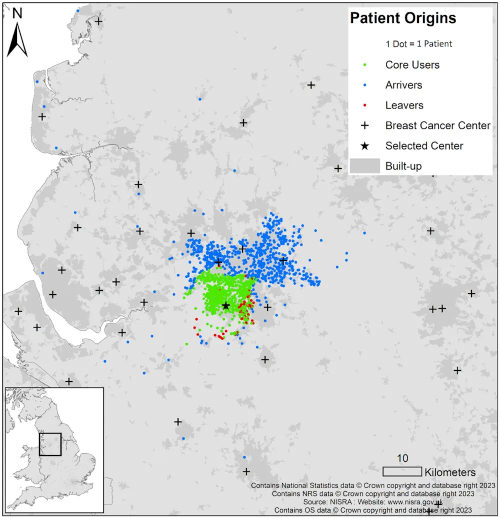
Many women undergoing breast-conserving surgery (BCS) or mastectomy bypass their nearest hospitals, according to a study published online Jan. 8 in Cancer. Ajay Aggarwal, M.D., Ph.D., from the London School of Hygiene and Tropical Medicine, and colleagues used linked administrative datasets from the English National Health Service to identify all women who underwent BCS or ...
healthday.com
Calgary Researchers Using High-Tech Drones To Map Alberta First Nation

Calgary Researchers Using High-Tech Drones To Map Alberta First Nation

Researchers and students at the Southern Alberta Institute of Technology are using sophisticated drones to digitally map Frog Lake First Nation. The nation, about 260 kilometres northeast of Edmonton, has relied on paper and low-resolution digital maps that no longer represent the community, according to the research team. “Maps are incredibly dynamic. They change quite ...
cbc.ca
The Sound Maps That Predict Poachers' Movements

The Sound Maps That Predict Poachers’ Movements

In the Upper Paraná Atlantic Forest lies the world-renowned Iguazu Falls. On one side of the towering cascades is the Iguazú National Park of Argentina, on the other is the Iguaçu National Park of Brazil. Greened by over 2,000 plant species, the landscape is home to an array of creatures, including the charismatic jaguar. And ...
bbc.com
Study From NYC To D.C. And Beyond, Cities On The East Coast Are Sinking

Study: From NYC To D.C. And Beyond, Cities On The East Coast Are Sinking

Major cities on the U.S. Atlantic coast are sinking, in some cases as much as 5 millimeters per year – a decline at the ocean’s edge that well outpaces global sea level rise, confirms new research from Virginia Tech and the U.S. Geological Survey. Particularly hard hit population centers such as New York City and ...
news.vt.edu
How Artificial Intelligence Can Help Beavers Fight Floods, Droughts And Wildfires

How Artificial Intelligence Can Help Beavers Fight Floods, Droughts And Wildfires

A few years ago, a couple of Google employees reached out to a Minnesota scientist with an unusual proposal: What if they could teach computers to spot beaver habitats from space? “They wanted to know if I thought it was possible to find beaver wetlands from aerial imagery myself, and then if that could be ...
cbc.ca
World’s First Map Of Industrial Ocean Use

World’s First Map Of Industrial Ocean Use

Illegal fishing practices through spoofing tracking devices in ships have become a common practice in the industrial use of our oceans. A new study published in the journal Nature corroborates the trend and offers a view of the changing oceanic activities and landscape. Led by Global Fishing Watch, a company founded by Google, the study ...
geospatialworld.net
Computer Vision And Neural Networks To Help Detect Crop Diseases

Computer Vision And Neural Networks To Help Detect Crop Diseases

A research team from Skoltech and Saint-Petersburg State University of Aerospace Instrumentation have presented a paper in which they pioneered an alternative method for detecting decayed and moldy apples at the post-harvest stage, when fruits are stored and then delivered to the customer. A computer vision system will determine different defects at the early stage, ...
phys.org
Soil Atlas Depicts The Distribution Of Chemical Elements In Swiss Soils

Soil Atlas Depicts The Distribution Of Chemical Elements In Swiss Soils

Agroscope and the Federal Office for the Environment have published the first Geochemical Soil Atlas of Switzerland. It provides an overview of the large-scale distribution of 20 naturally occurring chemical elements in Swiss soils. The soil atlas will help the cantonal environmental protection agencies assess soil pollution levels and take action where necessary. The Geochemical ...
admin.ch
Drones Help Solve The Forest Carbon Capture Riddle In Thailand

Drones Help Solve The Forest Carbon Capture Riddle In Thailand

On a hillside overlooking cabbage fields outside the northern Thai city of Chiang Mai, a drone’s rotors begin to whir, lifting it over a patch of forest. It moves back and forth atop the rich canopy, transmitting photos to be knitted into a 3D model that reveals the woodland’s health and helps estimate how much ...
aljazeera.com
A New Map Showing All Above-Ground Biomass In The Brazilian Amazon

A New Map Showing All Above-Ground Biomass In The Brazilian Amazon

Publication of a new map showing all the above-ground biomass in the Brazilian Amazon is good news in the context of the severe crisis afflicting the world’s largest contiguous tropical rain forest. Using airborne laser scanning and satellite imagery calibrated by field forest inventories and integrated by heavy-duty computer processing and machine learning, the map ...
labmanager.com
Brown Anthropologist’s Mapping Project Shows How Peru Transformed After Colonization

Brown Anthropologist’s Mapping Project Shows How Peru Transformed After Colonization

Parker VanValkenburgh has dedicated more than a decade of research to understanding how colonialism impacted Peru’s Indigenous people in the 16th century. That time marked a turning point in the region: Spanish forces conquered the Inca Empire, initiating a period of social violence and upheaval that included the forced resettlement of more than 2 million ...
brown.edu
Great Frigatebirds Wearing Backpacks Map The Atmosphere

Great Frigatebirds Wearing Backpacks Map The Atmosphere

Great frigatebirds live in tropical regions and routinely fly to 2,000 meters (1.25 miles) in altitude, occasionally reaching heights of 4,000 meters (2.5 miles). A new study shows that great frigatebirds equipped with tiny sensors can give detailed information about the planetary boundary layer (PBL), which is the dynamic atmospheric layer that is closest to ...
phys.org
To Understand How Animals Roam, Look At Human Movements, Study Says

To Understand How Animals Roam, Look At Human Movements, Study Says

To fully understand animal behavior and conservation, scientists are finding they need to study humans’ daily movements and activities. A paper published in Nature Ecology & Evolution brings together a multidisciplinary group of experts to examine how tracking human movements through landscapes over time can provide insights into wildlife behavior and conservation. This collaborative project ...
news.mongabay.com
¿A Qué Huele Málaga Un Proyecto Permitirá Elaborar El Primer Mapa De Olores De La Ciudad

¿A Qué Huele Málaga? Un Proyecto Permitirá Elaborar El Primer Mapa De Olores De La Ciudad

¿A qué huele Málaga? A esta pregunta tratará de responder la Fundación Aula del Mar Mediterráneo (FAMM), que realizará el primer mapa de olores de la ciudad gracias a la colaboración ciudadana y técnicas de ‘big data’, es decir, de macrodatos. La iniciativa se enmarca en el proyecto LifeWatch Eric y en ella pueden participar ...
laopiniondemalaga.es

Datos Satelitales Abiertos Permiten Desarrollar Modelo Que Conecta Polinización Y Terrenos Con Potencial Agrícola

Un innovador estudio que utiliza datos satelitales abiertos ayudará a desarrollar un modelo que integra la presencia de insectos polinizadores y la restauración de predios agrícolas. El estudio es de Laura Pérez, doctora en Ecología y Biología Evolutiva y postdoctorante de Data Observatory, Centro ANID, quien desarrolla hasta el 2025 esta investigación para una mejor ...
diariolagoranco.cl
New York Will Plant Thousands Of Trees Using New Tech To Maximize Foliage Impact

New York Will Plant Thousands Of Trees Using New Tech To Maximize Foliage Impact

New York City is poised to get a lot more trees. Last month, the city council passed a measure calling for 30% canopy cover by 2035, up from its current cover of 22% – which could mean 250,000 new trees. More trees, with all their cooling benefits, is a clear win for the environmental justice ...
theguardian.com
Satellite Remote Sensing Model For Wide-Area Prediction Of Transpiration Rates In Japanese Cypress Plantations

Satellite Remote Sensing Model For Wide-Area Prediction Of Transpiration Rates In Japanese Cypress Plantations

Forests, known as nature’s “green dams,” play a crucial role in replenishing Earth’s groundwater reserves. However, overcrowding in planted forests due to lack of maintenance activities, such as thinning practices, is a pressing concern in Japan. This overcrowding causes substantial water loss from these forests into the atmosphere through a combination of soil evaporation and ...
phys.org
Researchers Propose New Method for Large-Scale Urban Building Function Mapping Using Web-Based Geospatial Data

Researchers Propose New Method for Large-Scale Urban Building Function Mapping Using Web-Based Geospatial Data

In a pioneering study published in Geo-spatial Information Science, a research group led by Yuyu Zhou from The University of Hong Kong developed an integrated framework that achieves 94% accuracy in mapping building functions across 50 U.S. cities using multi-source web-based geospatial data, offering potential for worldwide application. The team utilized TripAdvisor.com and Google Maps ...
newswise.com