Geomaticians

Research

Designing A Decision-Support Tool For Climate Adaptive Urban Planning

Designing A Decision-Support Tool For Climate Adaptive Urban Planning

Heat stress and air pollution ravages cities more and more. In a new Horizon Europe project, researchers will develop a digital twin that supports decision makers to design resilient urban areas that can cope with the changing climate. Researchers from TU Delft and 18 other partners receive the Horizon Europe grant for their project called ...
tudelft.nl
Project To Show Insights Into New Zealand’s Exotic Forests

Project To Show Insights Into New Zealand’s Exotic Forests

A research project to capture an inventory of all exotic planted forests in New Zealand could provide a valuable tool for commercial forestry decisions. Crown Research Institute Scion showed Forest Insights at its stand at Mystery Creek in June, as part of the 2024 Fieldays Forestry Hub. Grant Evans is Scion’s new value digital forests ...
nzherald.co.nz
A Data-Driven Framework For An Enhanced Indoor Localisation And Positioning Precision

A Data-Driven Framework For An Enhanced Indoor Localisation And Positioning Precision

This invention presents a Wi-Fi Positioning System (WPS) that enables accurate indoor positioning via Wi-Fi signals, as GPS is often unreliable indoors. By employing novel data generation techniques, this system enhances the data collection process. It is applicable to products requiring indoor positioning, such as navigation, augmented reality and health applications. Indoor positioning is crucial ...
ntu.edu.sg
Researchers Forge More Open Access Data For Studies Of The Earth's Lithosphere

Researchers Forge More Open Access Data For Studies Of The Earth’s Lithosphere

Crust and lithospheric mantle—the thinnest and thickest layers of the Earth’s lithosphere—and a wide range of dynamic processes that deform them can be studied by using high precision geodetic data taken directly from Global Navigation Satellite Systems (GNSS). GNSS data and data products can measure and help the user understand such factors as the Earth’s ...
phys.org

UC Irvine Earth System Scientists Discover Missing Piece In Climate Models

As the planet continues to warm due to human-driven climate change, accurate computer climate models will be key in helping illuminate exactly how the climate will continue to be altered in the years ahead. In a study published in the Journal of Geophysical Research: Atmospheres, a team led by researchers from the UC Irvine Department ...
news.uci.edu
How Climate Change Is Altering The Earth's Rotation

How Climate Change Is Altering The Earth’s Rotation

The Earth’s spin axis is not constant. It moves slowly over time relative to the Earth’s crust. This is caused by various processes on the surface and inside the Earth, such as the melting of ice masses or the uplift of land masses, as well as mass shifts in the Earth’s viscous mantle and core. ...
gfz-potsdam.de
Artificial Intelligence Meets Cartography

Artificial Intelligence Meets Cartography

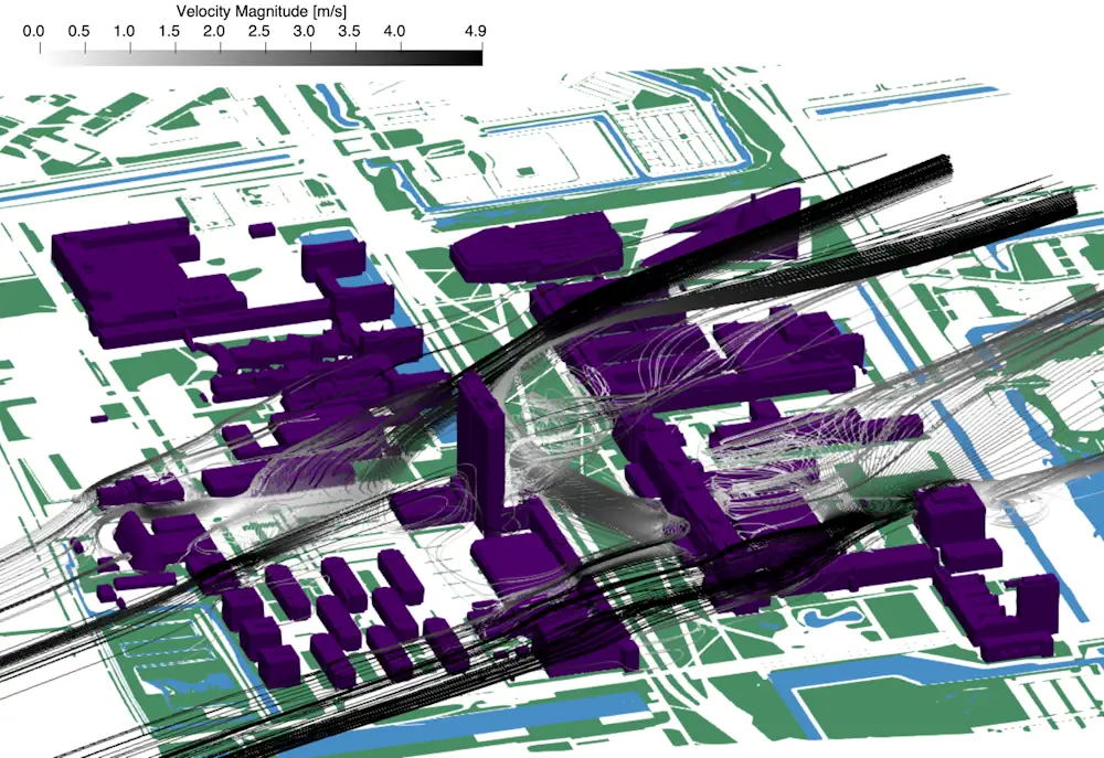
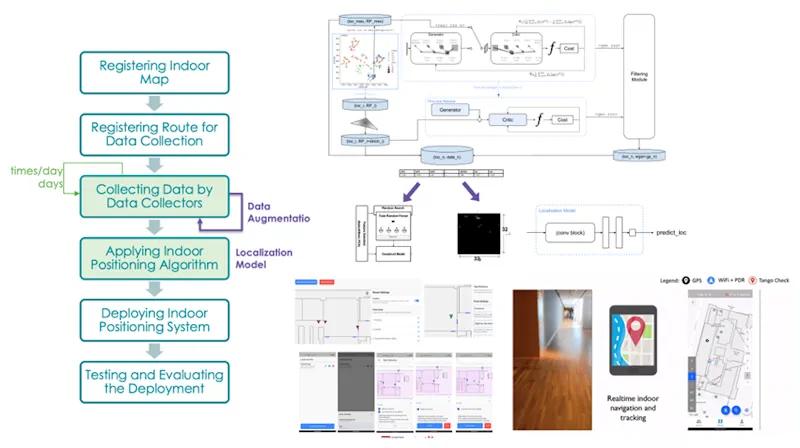
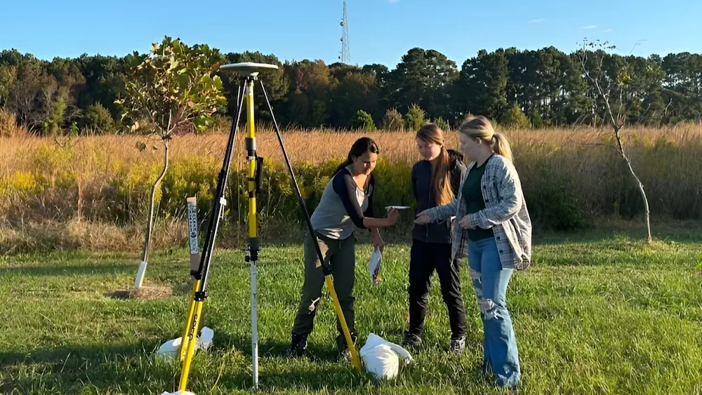
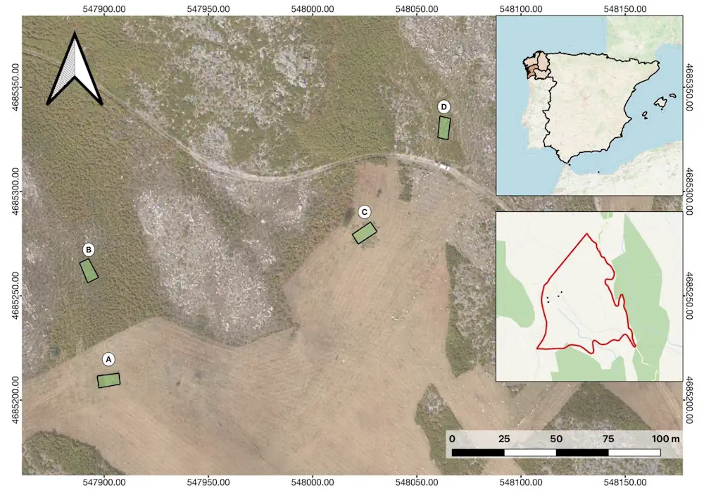
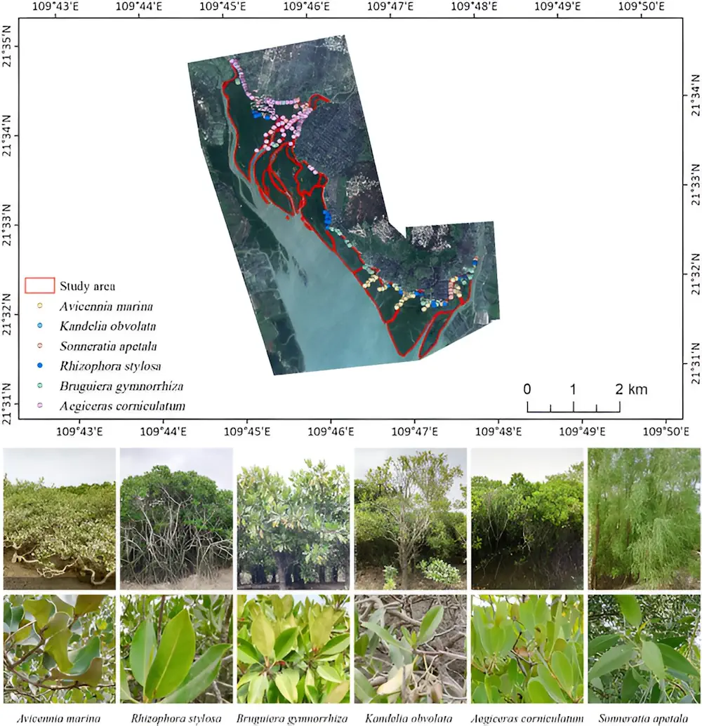
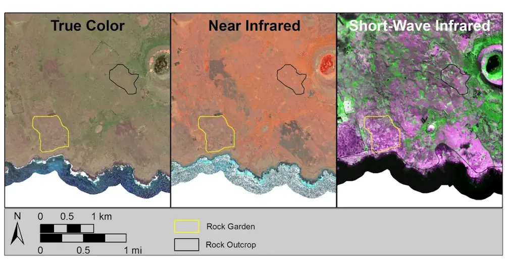
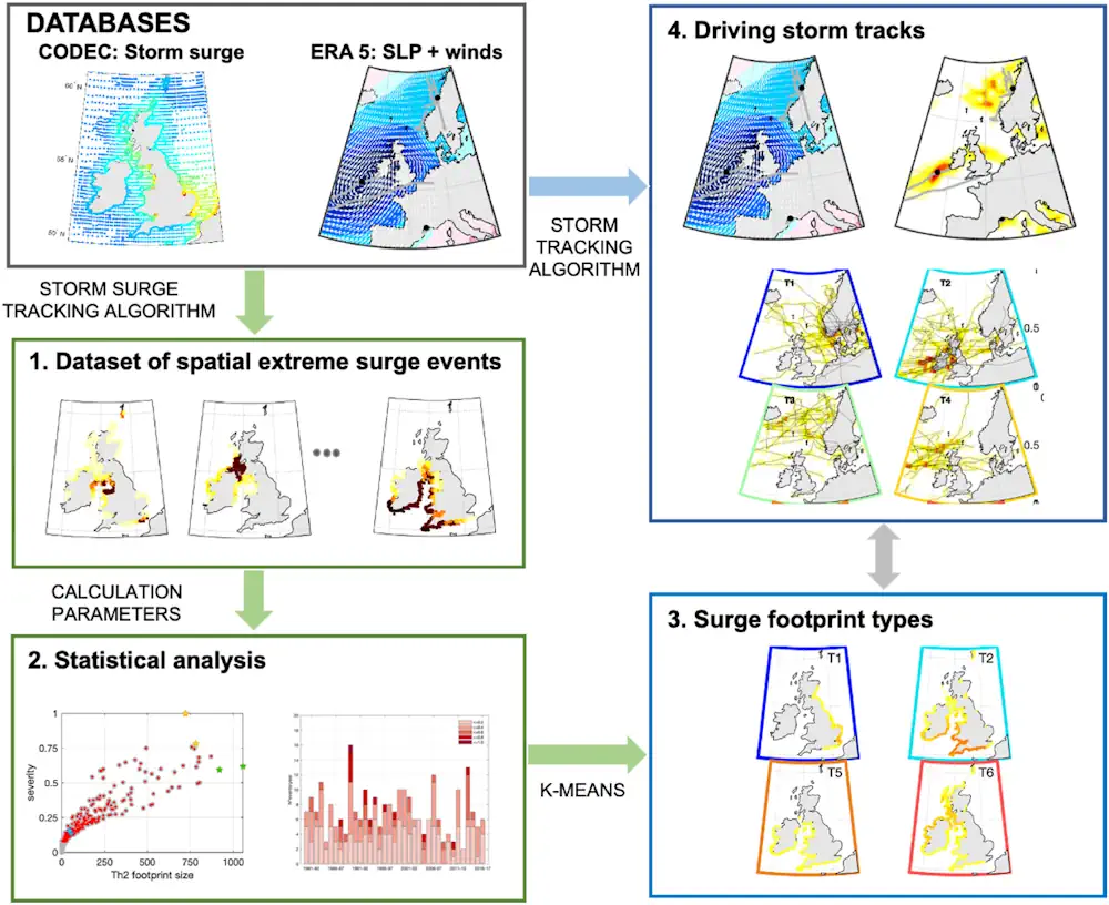
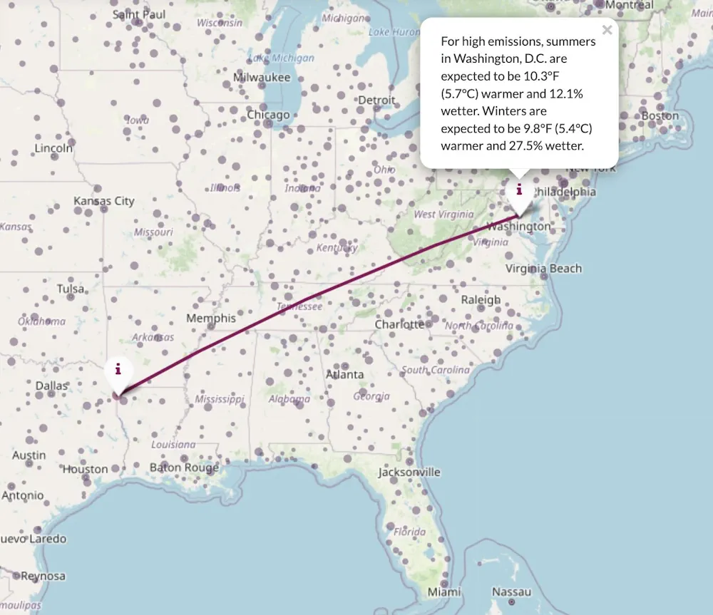
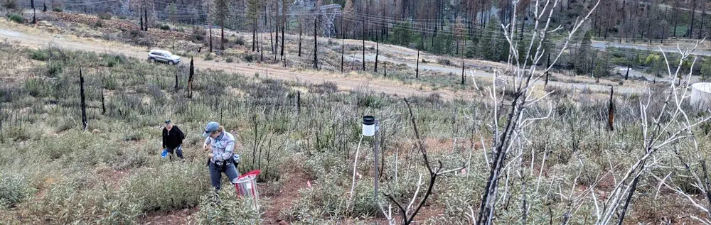
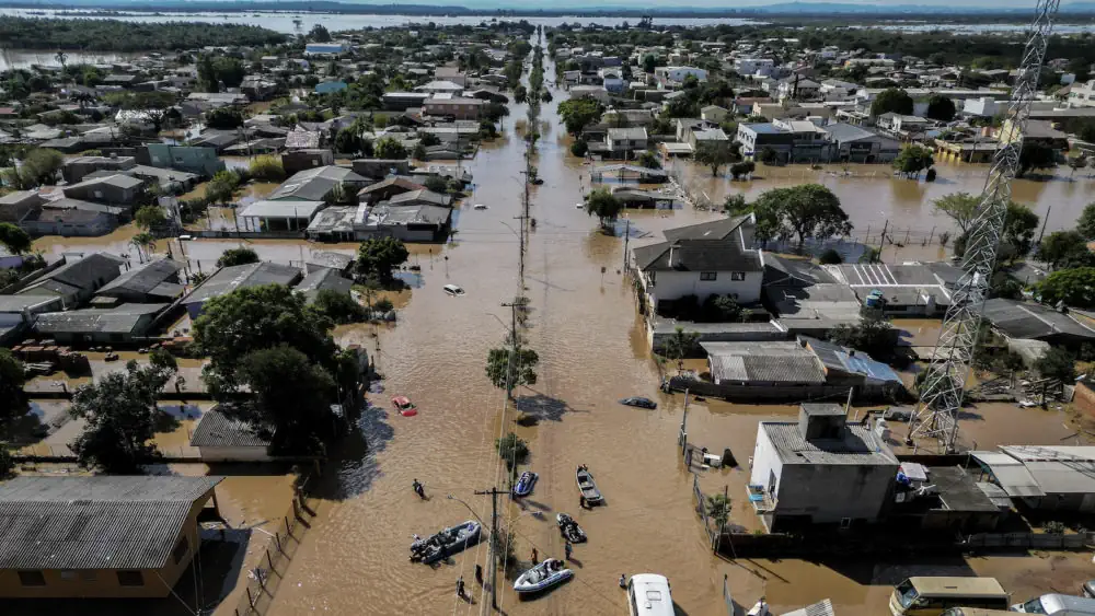
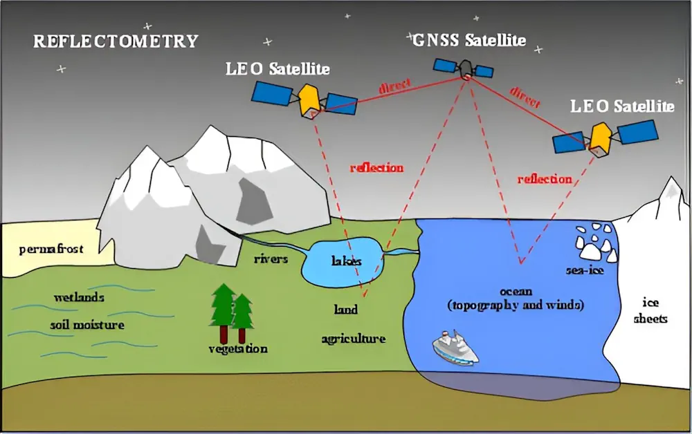
Most people interact with maps regularly, for example, when they’re trying to get from point A to point B, track the weather or plan a trip. But, beyond those daily activities, maps are also increasingly being combined with artificial intelligence to create powerful tools for urban modeling, navigation systems, natural hazard forecasting and response, climate ...
engineering.wustl.edu
Using Remote Sensing To Study How Wild Horses Reduce Shrub And Grassland Biomass

Using Remote Sensing To Study How Wild Horses Reduce Shrub And Grassland Biomass

Forests in Galicia, northwestern Spain, are frequently ravaged by wildfires, leading to significant environmental and economic damage. The increasing virulence of these fires, exacerbated by climate change, poses a heightened risk to both natural landscapes and human populations. Traditional forestry methods to mitigate these fires are costly, prompting the exploration of alternative measures. One such ...
naturalsciencenews.com
From Space To Swamp AI Method Classifies Mangrove Species With Unprecedented Accuracy

From Space To Swamp: AI Method Classifies Mangrove Species With Unprecedented Accuracy

Mangroves are crucial for biodiversity, climate change mitigation, and coastal protection but face threats from climate change and human activities. Traditional monitoring methods fall short in accurately capturing their complex features. The integration of advanced machine learning algorithms with multisource remote sensing data offers a promising solution. Based on these challenges, it is essential to ...
phys.org
Satellite Imagery May Provide A Missing Puzzle Piece In Easter Island Saga

Satellite Imagery May Provide A Missing Puzzle Piece In Easter Island Saga

Hundreds of monumental stone heads dot the coastline of the remote Pacific island of Rapa Nui, or Easter Island. Settled by a small group of Polynesian seafarers about 900 years ago, it’s a fascinating place that has been the subject of fierce debate about how complex societies can sometimes ruinously fail. Some experts, such as ...
edition.cnn.com
Scientists Analyze Record Storm Surges To Help Predict Future Flooding

Scientists Analyze Record Storm Surges To Help Predict Future Flooding

Researchers at the University of Southampton have conducted the most detailed spatial analysis to date of storm surges along the coast of the UK and Ireland. The oceanographers found that coastlines in the north of the Irish Sea experience the longest and largest surges, while those occurring around the southwest coast of England have the ...
eurekalert.org
Interactive Map Shows Future Climate Of Your City Based On Emissions Scenarios

Interactive Map Shows Future Climate Of Your City Based On Emissions Scenarios

The impacts of climate change are being felt all over the world, but how will it impact how your hometown feels? An interactive web application from the University of Maryland Center for Environmental Science allows users to search 40,581 places and 5,323 metro areas around the globe to match the expected future climate in each ...
phys.org

Un Estudio De La Universitat Politècnica De Valencia Alerta Del Negativo Impacto Del Turismo Masivo En El Patrimonio Histórico

Un estudio liderado por el Centro de Investigación PEGASO de la Universitat Politècnica de València (UPV) advierte de la “emergente necesidad” de identificar medidas preventivas que ayuden a garantizar la conservación de los edificios patrimoniales y a mejorar la gestión turística de dichos inmuebles y de los centros históricos de las ciudades. Realizado en el ...
elperiodicodeaqui.com
AI Shows How Field Crops Develop

AI Shows How Field Crops Develop

Researchers at the University of Bonn have developed software that can simulate the growth of field crops. To do this, they fed thousands of photos from field experiments into a learning algorithm. This enabled the algorithm to learn how to visualize the future development of cultivated plants based on a single initial image. Using the ...
eurekalert.org
New Way To Spot Beetle-Killed Spruce Can Help Forest, Wildfire Managers

New Way To Spot Beetle-Killed Spruce Can Help Forest, Wildfire Managers

A new machine-learning system developed at the University of Alaska Fairbanks can automatically produce detailed maps from satellite data to show locations of likely beetle-killed spruce trees in Alaska, even in forests of low and moderate infestation where identification is otherwise difficult. The automated process can help forestry and wildfire managers in their decisions. That’s ...
phys.org
When In Drought Researchers Map Which Parts Of The Amazon Are Most Vulnerable To Climate Change

When In Drought: Researchers Map Which Parts Of The Amazon Are Most Vulnerable To Climate Change

In the late 2000s, Scott Saleska observed an unusual phenomenon in the Amazon rainforest. A severe drought in 2005 led to increased green growth in vast areas of the Amazon, contrary to field researchers’ observations of browning plants and some dying due to the drought. Recent research published in Nature by Shuli Chen, a doctoral ...
phys.org
Planetary Boundary Layer Revealed Satellites Illuminate Atmospheric Mysteries

Planetary Boundary Layer Revealed: Satellites Illuminate Atmospheric Mysteries

Unlocking the secrets of Earth’s planetary boundary layer (PBL), a pivotal zone influencing air quality and climate, a new study offers unprecedented insights into atmospheric thermal contrasts (TC). By scrutinizing satellite data, researchers have shed light on how the surface-to-atmosphere temperature gradient affects the detection of atmospheric pollutants. The endeavor to keep tabs on and ...
eurekalert.org
Study Reveals Stable Soil Moisture Variability Within Fields, Opens Door For Satellite Remote Sensing

Study Reveals Stable Soil Moisture Variability Within Fields, Opens Door For Satellite Remote Sensing

A multi-institutional study led by University of Illinois and Agroecosystem Sustainability Center (ASC) scientists concluded that, although soil moisture varies significantly both within a single field and from field to field due to varying soil properties and different management practices, soil moisture distribution relative to the field average remains consistent across time within each field. ...
phys.org
Madatlas Digital Cartography For Madagascar

Madatlas: Digital Cartography For Madagascar

An ambitious project launched in 2021, Madatlas aims to build an LMD training program in digital cartography at the University of Fianarantsoa. With the aim of enabling the Malagasy people to play an active role in the creation of a digital atlas of the island, Madatlas has given rise to training, research and partnerships between ...
univ-gustave-eiffel.fr
Using Drones Will Advance The Inspection Of Remote Runways In Canada And Beyond, Research Suggests

Using Drones Will Advance The Inspection Of Remote Runways In Canada And Beyond, Research Suggests

With weather, limited flights and long distances, gravel runways at remote airports—particularly in northern Canada—are difficult to get to, let alone to inspect for safety. So Northeastern University researcher Michal Aibin and his team have developed a more thorough, safer and faster way to inspect such runways using drones, computer vision and artificial intelligence. The ...
techxplore.com
School Of Geosciences Professor Leads Permafrost Thaw Study

School Of Geosciences Professor Leads Permafrost Thaw Study

A research initiative, funded by NASA and the Army Corps of Engineers, is underway to study permafrost thaw in Alaska and its significant impacts on the environment. This project aims to understand the landforms created by thawing permafrost, how it affects methane emissions and whether the rate of permafrost thaw is accelerating. Leading this research ...
usf.edu
Researchers Leverage Shadows To Model 3D Scenes, Including Objects Blocked From View

Researchers Leverage Shadows To Model 3D Scenes, Including Objects Blocked From View

Imagine driving through a tunnel in an autonomous vehicle, but unbeknownst to you, a crash has stopped traffic up ahead. Normally, you’d need to rely on the car in front of you to know you should start braking. But what if your vehicle could see around the car ahead and apply the brakes even sooner? ...
news.mit.edu
Remote Sensing Characterization Of Post-Fire Vegetation Recovery

Remote Sensing Characterization Of Post-Fire Vegetation Recovery

Remote sensing is a powerful tool to measure fire’s effects on plant life. How severe was the damage to vegetation? How quickly can a landscape recover? A new project is looking at those questions from a before, during, and after fire perspective, and the Wildland Fire Team at EROS investigates how using different remote sensing ...
usgs.gov
Scientists Have Built A ‘Digital Twin’ Of Earth To Predict The Future Of Climate Change

Scientists Have Built A ‘Digital Twin’ Of Earth To Predict The Future Of Climate Change

Scientists have built a highly accurate digital simulation of planet Earth to provide reliable information about extreme weather and climate change. This AI-powered “digital twin” virtually simulates the interaction between natural phenomena and human activities to predict their effect on things like water, food and energy systems. In the past, climate and weather predictions have ...
euronews.com
How A ‘Citizen Map’ Is Helping Brazil Prepare For Next Big Flood

How A ‘Citizen Map’ Is Helping Brazil Prepare For Next Big Flood

In the wake of last month’s disastrous flooding in southern Brazil, researchers are asking residents to use their smartphone cameras to document the damage and high-water marks. The data collected will help scientists map flood risk and inform decisions on where to rebuild. When Lucas George Wendt arrived in Lajeado in late May, the water ...
e360.yale.edu
Shape And Depth Of Ocean Floor Profoundly Influence How Carbon Is Stored There

Shape And Depth Of Ocean Floor Profoundly Influence How Carbon Is Stored There

The movement of carbon between the atmosphere, oceans and continents — the carbon cycle — is a fundamental process that regulates Earth’s climate. Some factors, like volcanic eruptions or human activity, emit carbon dioxide into the atmosphere. Others, such as forests and oceans, absorb that CO2. In a well-regulated system, the right amount of CO2 ...
newsroom.ucla.edu
New NASA Mission To Map Earth’s Surface In 3D Moves One Step Closer

New NASA Mission To Map Earth’s Surface In 3D Moves One Step Closer

The Earth Dynamics Geodetic Explorer (EDGE)—a newly proposed NASA satellite mission to monitor the three-dimensional structure of global vegetation and ice—is one of four finalists selected for NASA’s next generation of Earth-observing satellites under the Earth System Explorers Program. The project, which includes Northern Arizona University assistant research professor Chris Hakkenberg as co-investigator and biodiversity ...
news.nau.edu
Study Reviews Current State Of Global Navigation Satellite System Reflectometry

Study Reviews Current State Of Global Navigation Satellite System Reflectometry

Global navigation satellite system reflectometry (GNSS-R) is emerging as a pivotal technology in remote sensing due to its ability to provide high-precision, real-time data under all weather conditions. Traditionally, the GNSS has been utilized for positioning, navigation, and timing. However, recent advancements have demonstrated its efficacy in environmental monitoring through scatterometry and reflectometry. GNSS-R capitalizes ...
phys.org

Comparing Sandy Beach And Dune Changes Using Lidar And Drone Technology

Coastal landscapes, including sandy beaches and foredunes, are dynamic and susceptible to changes caused by water level fluctuations, storm events, and human activities. Monitoring these changes is crucial for effective coastal management and resilience planning. Traditional methods for measuring geomorphic changes, such as small-unoccupied aircraft systems paired with structure-from-motion photogrammetry (sUAS-SfM), are often costly and ...
naturalsciencenews.com
Internet Of Waste SLU Researcher Uses AI To Tackle STL’s Waste And Recycling Problem

Internet Of Waste: SLU Researcher Uses AI To Tackle STL’s Waste And Recycling Problem

Neighborhoods in the City of St. Louis will soon be able to track their recycling and solid waste thanks to a geospatial sensor developed by a Saint Louis University researcher. Orhun Aydin, Ph.D., assistant professor in Earth and Atmospheric Science at SLU’s School for Science and Engineering, received a $149,791 planning grant from the National ...
firstalert4.com