Geomaticians

Event

The Integrated Transport Centre Signs A MoU With A Leading Japanese Company “Location Mind” In Research And Development

On the sidelines of the 10th session of the Abu Dhabi Japan Economic Council, held in the capital Abu Dhabi, the Integrated Transport Centre (ITC) of the Department of Municipalities and Transport (DMT) in Abu Dhabi signed a strategic Memorandum of Understanding (MoU) with “Location Mind”, a leading Japanese company in the field of research, ...
zawya.com
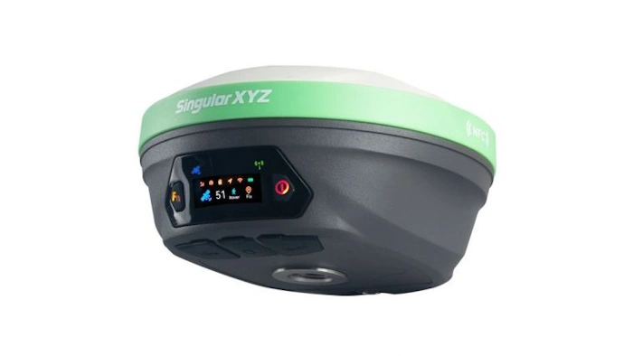
X1 Pro GNSS Receiver Enhances Surveying Precision

X1 Pro GNSS Receiver Enhances Surveying Precision

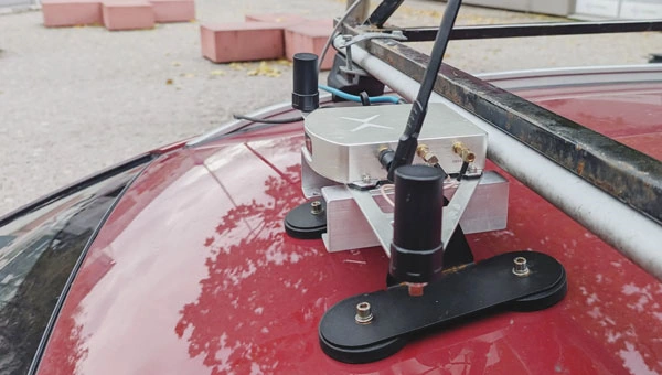
SingularXYZ has presented its latest innovation for geospatial professionals: the X1 Pro GNSS receiver. This new device aims to refine precision in surveying technology with a range of features tailored to streamline operations and improve accuracy. Central to the X1 Pro is its enhanced HD colour screen, providing users with clear visibility for monitoring status ...
gim-international.com

S. Korea, Japan To Cooperate In Developing Satellite Navigation System

South Korea and Japan will collaborate on the development and operation of regional satellite navigation systems in East Asia, Seoul’s science ministry said Tuesday. The two countries signed a memorandum of cooperation (MOC), designed for practical cooperation in developing and operating their respective satellite systems in the region, according to the Ministry of Science and ...
en.yna.co.kr

Geospatial Mapping And AI To Help Tackle Energy Gap In Africa

Energy modellers and researchers have developed a geospatial mapping model they say can help address the electricity access gap in Africa. The model has been developed by the International Energy Agency (IEA), researchers at Massachusetts Institute of Technology, University of Massachusetts Amherst and Electricity Growth and Use In Developing Economies. By mapping which buildings are ...
esi-africa.com

New PSGA Data Will Help Speed Up Emergency Response Times

A new selection of location datasets, including two new products, have been released today (Thursday 28 March) as part of the Public Sector Geospatial Agreement (PSGA). The new data and products have been delivered by Ordnance Survey (OS) and are set to support customers across a range of markets, including the emergency services, sustainability, land ...
gov.uk

Dublin Urban Rivers Life Project Selects ESRI To Reduce Levels Of Wastewater

Geographic information systems (GIS) provider Esri Ireland has been chosed by Dublin Urban Rivers Life (DURL) project to help prevent preventing circa 13 million litres of polluted wastewater from entering Dublin rivers annually. DURL is a joint venture between South Dublin and Dún Laoghaire-Rathdown County Councils, with funding received from the EU Life Programme. It ...
techcentral.ie

Geospatial Commission-Funded Tool Demonstrates Potential For AI To Transform Decisions About Land Use

The Geospatial Commission, part of the Department for Science, Innovation and Technology (DSIT), has partnered with The Alan Turing Institute to explore the role that artificial intelligence (AI) can play in long-term decisions about how to use land. The UK is facing significant and competing pressures for its land. Advances in spatial data science and ...
gov.uk

NVIDIA Announces Earth Climate Digital Twin

To accelerate efforts to combat the $140 billion in economic losses due to extreme weather brought on by climate change, NVIDIA today announced its Earth-2 climate digital twin cloud platform for simulating and visualizing weather and climate at unprecedented scale. Part of the NVIDIA CUDA-X™ microservices, announced separately today, Earth-2’s new cloud APIs on NVIDIA ...
nvidianews.nvidia.com
Crean Plataforma Para Democratizar La Información Histórica De Bogotá De Hace Más De Dos Siglos

Crean Plataforma Para Democratizar La Información Histórica De Bogotá De Hace Más De Dos Siglos

Con la intención de acercar y facilitar el acceso a toda la información de Bogotá, la Sociedad de Mejoras y Ornato de Bogotá creó la plataforma digital DataCivilidad, una herramienta que recoge cientos de miles de datos de la capital desde hace más de dos siglos para que, tanto personas naturales como organizaciones estatales y ...
diariodelcauca.com.co

Investigadores De La UJA Y Guatemala Colaboran En El Desarrollo De Técnicas Que Ayuden A Documentar Y Preservar El Patrimonio

Los grupos de investigación ‘Informática Gráfica y Geomática’ y ‘Tecnologías Avanzadas en Ingeniería Civil: Construcción y Transporte Terrestre’ de la Universidad de Jaén mantienen desde hace unos años una intensa colaboración en materia de investigación y docencia con la Facultad de Arquitectura de la Universidad de San Carlos de Guatemala (FARUSAC). Fruto de esta cooperación ...
ondacerojaen.es
Trimble And Radiodetection Combine Survey-Grade Positioning With Underground Utilities Locating Measurement Workflows

Trimble And Radiodetection Combine Survey-Grade Positioning With Underground Utilities Locating Measurement Workflows

Trimble and Radiodetection announced today a collaboration to improve the technology used in the utility measurement and mapping process. Through the integration of the Trimble® Catalyst™ DA2 GNSS system and Radiodetection’s RD MapTM+ application and precision locator products, the software and hardware integration streamlines utility-locating workflows to provide high-accuracy measurement capabilities for the creation of ...
directionsmag.com
AI And Drones Aid Farmers With Identifying Botrytis

AI And Drones Aid Farmers With Identifying Botrytis

Researchers from Unmanned Valley, Greenport DB, and NL Space Campus in the Netherlands have successfully developed an AI model that enables drones to identify the disease botrytis. The model leverages artificial intelligence to analyze vast amounts of drone data, resulting in a detailed map that pinpoints, with millimeter precision, which plants are diseased or at ...
futurefarming.com

Conferenza Nazionale Di Geomatica E Informazione Geografica #ASITA2024 Primo Annuncio E Call For Abstract

ASITA è il luogo dove professionisti, docenti, ricercatori, tecnici e professionisti, soggetti istituzionali e territoriali, società commerciali e più in generale tutti coloro che operano nei diversi campi della Geomatica possono confrontarsi su temi specifici, promuovendo una visione multidisciplinare e integrata del settore della Geomatica nel tentativo di delineare le cosiddette “best practices” utili ad ...
rivistageomedia.it
Klau Geomatics Introduces Brumby Mobile Mapping System

Klau Geomatics Introduces Brumby Mobile Mapping System

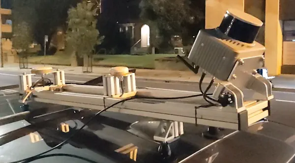
Klau Geomatics has introduced the Brumby RTK Lidar system, an innovative mobile mapping solution equipped with powerful Edge Compute capabilities, enabling the generation of highly precise georeferenced point clouds in real time. Brumby can be deployed on drones, light aircraft or as a mobile mapping system (MLS). It processes data into a georeferenced point cloud ...
gim-international.com

Iceye Launches Radar Satellite Service To Monitor The High Seas

Iceye, a company that builds and operates a constellation of microsatellites equipped with synthetic aperture radar (SAR) sensors, has launched a new maritime surveillance product called Ocean Vision. The service, announced March 7, aims to provide comprehensive monitoring of the world’s oceans. SAR satellites detect the signatures of vessels that stand out against the dark ...
spacenews.com
Fujitsu And Carnegie Mellon University Develop AI-Powered Social Digital Twin Technology With Traffic Data From Pittsburgh

Fujitsu And Carnegie Mellon University Develop AI-Powered Social Digital Twin Technology With Traffic Data From Pittsburgh

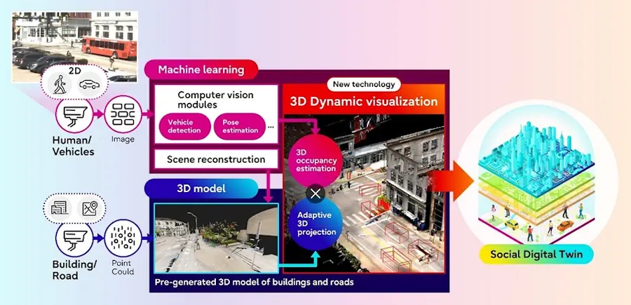
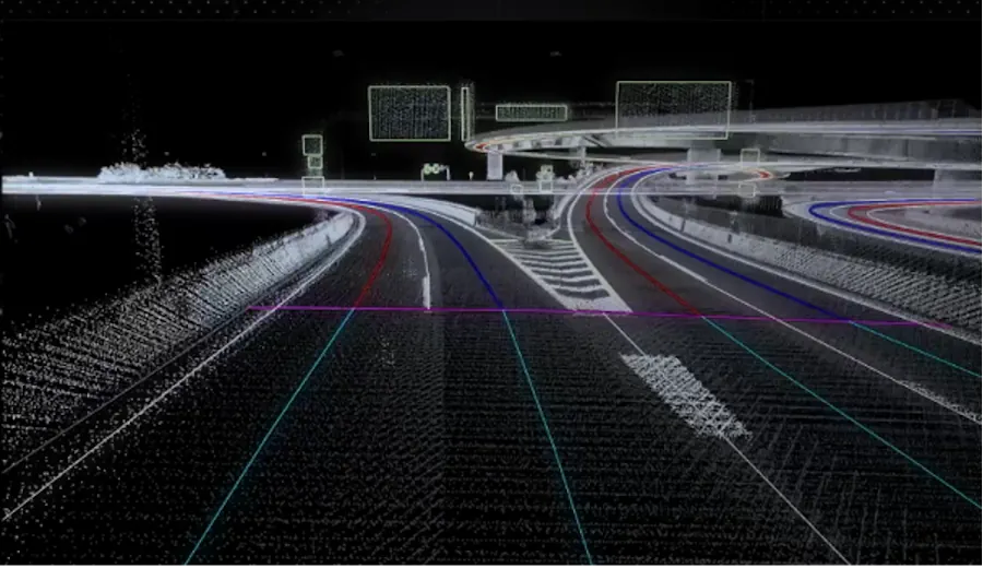
Fujitsu Limited and Carnegie Mellon University today announced the development of a new technology to visualize traffic situations, including people and vehicles, as part of joint research on Social Digital Twin that began in 2022. The technology transforms a 2D scene image captured by a monocular RGB camera (1) into a digitalized 3D format using ...
fujitsu.com
Scientific Systems Advances Navigation Software

Scientific Systems Advances Navigation Software

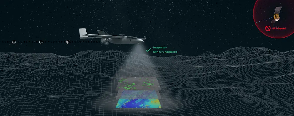
Scientific Systems has released upgrades for ImageNav, an image-based navigation software designed for GPS-denied or compromised environments. With more than a decade of development, ImageNav offers a robust alternative to traditional GPS navigation for military operations, particularly in contested environments where jamming poses a threat to GPS reliability. The demand for such technology has become ...
gpsworld.com

Philsa, DENR Team Up To Create Mangrove Map Using Satellite Data

The Philippine Space Agency (PhilSA) and the Department of Environment and Natural Resources (DENR) have collaborated to develop a nationwide mangrove map using remote sensing data, a vital tool for conservation efforts. The mangrove mapping initiative is part of the DENR’s development of a national geospatial database for its environment and natural resource accounting program. ...
philstar.com

Portugal To Launch Satellite

“Aeros”, a 4.5-kilo nanosatellite, took off from the SpaceX company base in Vandenberg, in the United States, at 9:18 pm on March 4th (Lisbon time). “Aeros” will be in Earth’s orbit at an altitude of 510 kilometers, slightly above the International Space Station. Communications and collection of data and images will be carried out from ...
theportugalnews.com
Google Maps Tests Showing Building Entrances

Google Maps Tests Showing Building Entrances

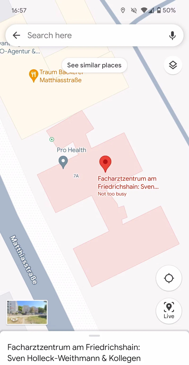
Google Maps has become an invaluable tool to navigate and to find the best spots to eat, get coffee, or to see sights. But with some bigger buildings and attractions, it can get hard to find the entrance. That’s where a new experiment comes in that Google appears to be testing with a few users ...
androidpolice.com
Australian Space Startup Esper Wants To Build Hyperspectral Sats For Cheap

Australian Space Startup Esper Wants To Build Hyperspectral Sats For Cheap

Australian remote sensing startup Esper wants to capture hyperspectral imagery from space at a fraction of the price of its competitors. The company, which launched its first demonstration satellite this Monday on SpaceX’s Transporter-10 mission, is entering a field rife with competition. There’s a reason for that: Hyperspectral is an incredibly powerful type of remote ...
techcrunch.com
ماهواره پارس۱ از پایگاه فضایی وستوچنی روسیه پرتاب شد

ماهواره پارس۱ از پایگاه فضایی وستوچنی روسیه پرتاب شد

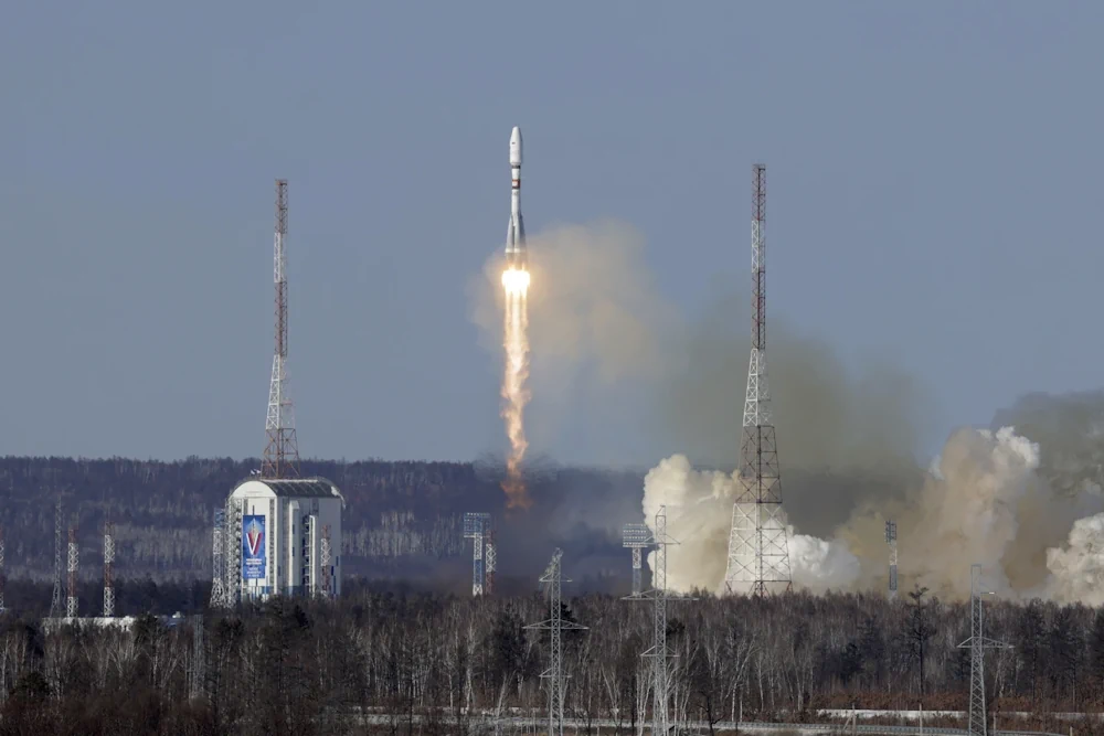
ماهواره سنجشی پارس۱ صبح پنج شنبه توسط پرتابگر روسی سایوز از پایگاه وستوچنی در شرق این کشور پرتاب شد. به گفته حسن سالاریه، رئیس سازمان فضایی ایران، ماهواره پارس یک، ماهواره سنجش از دور است که به سه محموله تصویربرداری تجهیز شده است: دوربین رنگی با دقت ۱۵ متر، دوربین مادون‌قرمز موج کوتاه با دقت ...
pvst.ir
IHME, Microsoft, And Planet Collaborate To Map Climate-Vulnerable Populations In Unprecedented Detail

IHME, Microsoft, And Planet Collaborate To Map Climate-Vulnerable Populations In Unprecedented Detail

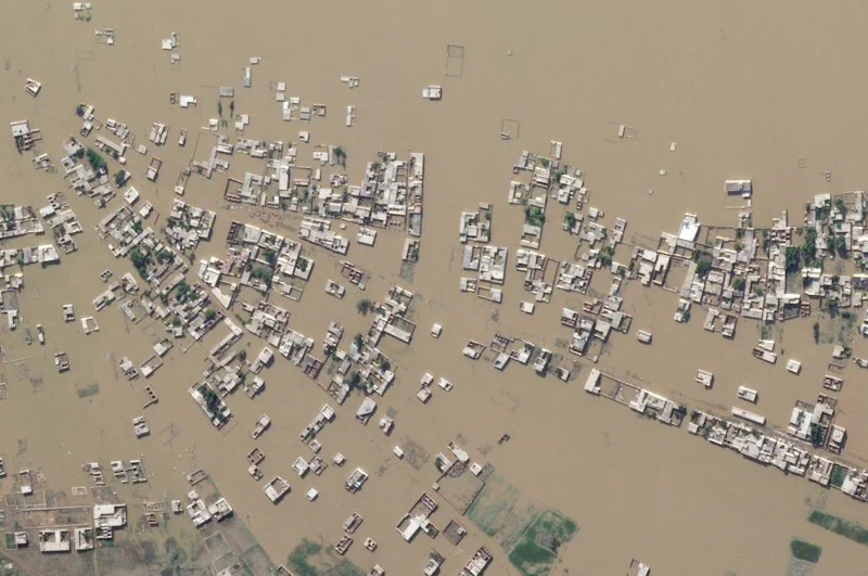
Climate change intensifies disasters, which drives displacement. That can, among many impacts, push internally displaced people from rural areas into urban slums. That in turn raises the risks of forced evictions and secondary urban displacement, as well as increased risks of public health crises, and so on, in a dispiriting causal chain. Knowing, in detail, ...
planet.com
Synspective + Dynamic Map Platform Selected For Enterprise Innovation Promotion Program

Synspective + Dynamic Map Platform Selected For Enterprise Innovation Promotion Program

Synspective Inc. (Synspective) and Dynamic Map Platform Co., Ltd. (Dynamic Map Platform) have been selected by the Japanese Ministry of Land, Infrastructure, Transport and Tourism for the Small and Medium Enterprise Innovation Promotion Program. This project leverages SAR satellite technologies and Synspective’s Land Displacement Monitoring (LDM) solution and aims to integrate these technologies with HD ...
news.satnews.com

MoSPI Signs MoU With ISRO On Urban Frame Survey Using Bhuvan

The NSSO (FOD) under Ministry of Statistics and Programme Implementation (MoSPI) has entered into a Memorandum of Understanding (MoU) with the National Remote Sensing Centre (NRSC) under the Indian Space Research Organization (ISRO) to facilitate Urban Frame Survey (UFS) in a digital mode using the state-of-the-art Geo ICT tools and techniques using Bhuvan Platform. The ...
pib.gov.in

GeoComm And Rapidsos Empower Emergency Communications Centers With Enhanced Indoor Maps

GeoComm, provider of Public Safety Location Intelligence, and RapidSOS, creator of the world’s first intelligent safety platform, are excited to announce the integration of GeoComm Indoor Maps into RapidSOS premium. Currently, telecommunicators in the U.S. are typically provided limited building structure information during a 9-1-1 call. An address point on a map with no additional ...
police1.com
Biodiversity Survey Tool For Meeting New Net Gain Obligations

Biodiversity Survey Tool For Meeting New Net Gain Obligations

Esri UK partner Temple has created a biodiversity assessment tool, which could assist construction and engineering firms in meeting the biodiversity net gain (BNG) legislation that came into effect in England earlier this year. Environment, planning and sustainability consultancy Temple has joined geographic information system (GIS) software provider Esri UK’s partner network. This allows Temple ...
geplus.co.uk

AGI Launch Awards For Geospatial Excellence

The Association for Geographic Information (AGI) has re-launched its highly popular awards for excellence within the geospatial sector. Entries for the awards are being sought from organisations and individuals, working in or with geospatial, who want to showcase innovation, achievements and best practice. The AGI 2024 Awards Categories are the ‘Chairperson’s Award for Outstanding Service ...
directionsmag.com
Mosaic, Movella Improve Mobile Mapping And Geospatial Analysis

Mosaic, Movella Improve Mobile Mapping And Geospatial Analysis

Mosaic and Movella have collaborated to combine the Mosaic 51 and Mosaic X camera systems with Movella’s Xsens Vision Navigator (XVN). The collaboration aims to bolster GIS platform integration and allow for extensive and precise 3D reconstruction. It uses inertial measuring unit (IMU) data generated by XVN and directly connects to the OBD port. The ...
gpsworld.com

Google Maps Is Finally Making Glanceable Directions Widely Available

Google developers have invested significant efforts in improving the navigation experience in Maps throughout 2023, as we witnessed with the journey behind creating Immersive View. Efforts like this make Maps one of our favorite navigation apps on Android, but along the way, it also announced features like glanceable directions, which we haven’t seen on our ...
androidpolice.com