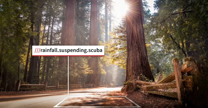
Last Week, The California State Parks System (CSP) Announced The Addition Of Location Technology To Improve Rescue Operations And The Park Visitor Experience. In Recent Years, New Technologies Like Drones And Robots Are Being Used In Places Like Travis County, Texas, To Improve Search And Rescue Operations. The Location Technology From What3words Has Been Implemented To Improve Public Safety In Places Like Dallas And Los Angeles, Dividing The World Into A Grid Of 10-foot By 10-foot Squares That All Bear A Unique Combination Of Three Words. CSP Has Been Working To Innovate The Visitor Experience With Technology, Including The Launch Of An Augmented Reality Mobile App Experience In June. The Addition Of What3words Adds Another Tech Tool To Support Visitors In California’s 280 State Parks.
There are two primary reasons CSP adopted this technology, according to CSP Assistant Deputy Director of Park Operations Adrien Contreras. The first is public safety. “Every year, we have folks that do get lost on trails,” said Contreras. “So, the ability to have someone identify a very specific 10-by-10 location in the middle of wide-open wilderness in a park unit is obviously a massively important public safety tool that can make our jobs much easier and could potentially save a life.” The second reason for adopting the tool is that it can help visitors communicate their specific location, such as a specific picnic table or campground, when meeting up with other park visitors in a California state park. The official CSP app now displays what3words addresses for over 8,000 points of interest in the state park system.