Geomaticians

Swiss Federal Institute of Technology in Zürich

How Climate Change Is Altering The Earth's Rotation

How Climate Change Is Altering The Earth’s Rotation

The Earth’s spin axis is not constant. It moves slowly over time relative to the Earth’s crust. This is caused by various processes on the surface and inside the Earth, such as the melting of ice masses or the uplift of land masses, as well as mass shifts in the Earth’s viscous mantle and core. ...
gfz-potsdam.de
Scientists Map Biodiversity Changes In The World's Forests

Scientists Map Biodiversity Changes In The World’s Forests

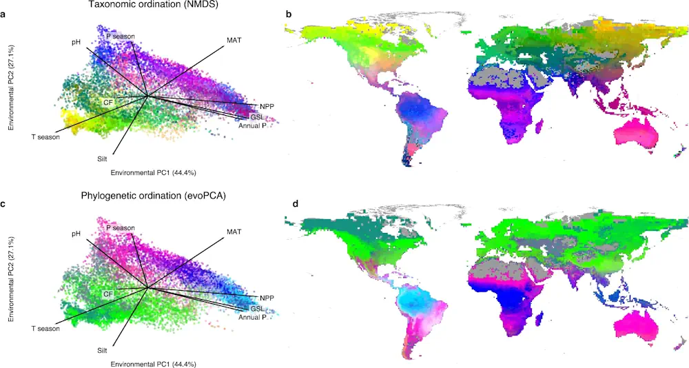
A group of EPFL and ETH Zurich scientists have mapped the biodiversity in forests worldwide. Their data, when combined with climate projections, reveal trends that could support ecosystem conservation and restoration efforts. According to the latest figures from the Food and Agriculture Organization of the United Nations, forests cover just over 4 billion hectares of ...
phys.org
Researchers From ETH Zurich And Google Introduce InseRF A Novel AI Method For Generative Object Insertion In The NeRF Reconstructions Of 3D Scenes

Researchers From ETH Zurich And Google Introduce InseRF: A Novel AI Method For Generative Object Insertion In The NeRF Reconstructions Of 3D Scenes

In 3D scene generation, a captivating challenge is the seamless integration of new objects into pre-existing 3D scenes. The ability to modify these complex digital environments is crucial, especially when aiming to enhance them with human-like creativity and intention. While adept at altering scene styles and appearances, earlier methods falter in inserting new objects consistently ...
marktechpost.com
Swiss Unis Develop Population Density Tool To Help Humanitarian Work

Swiss Unis Develop Population Density Tool To Help Humanitarian Work

EPFL researchers, along with scientists from the Federal Technology Institute ETH Zurich and Qatar’s Bin Khalifa University, thus worked on an artificial intelligence tool which can estimate population density and help reconstruction or crisis management efforts. The programme – as outlined in the Scientific Reports journal – uses data gleaned via remote sensing concerning factors ...
swissinfo.ch