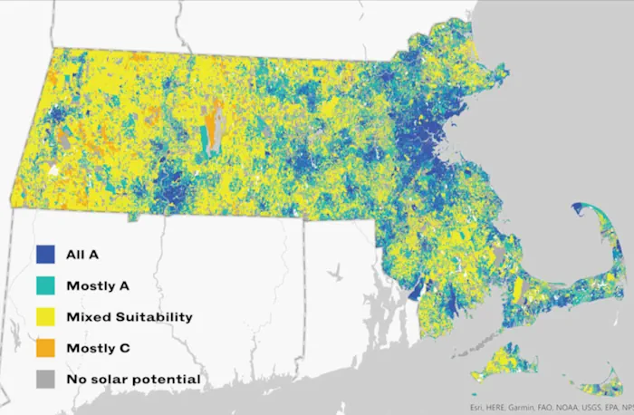
For Massachusetts to meet it ambitious clean energy goals, the state needs to build between 25 and 35 gigawatts of solar capacity by 2050. Currently, there are about 3 gigawatts installed — so it’s a tall order. But according to a new study from the state's Department of Energy Resources, there’s more than enough suitable land (and rooftops) to build what the state needs without compromising sensitive environmental areas, farmland and other valuable natural resources. “With the study results, we can be strategic about where and what kinds of solar we deploy,” Elizabeth Mahony, commissioner of the Department of Energy Resources, said in a statement. “This tool allows us to identify pockets where the most suitable solar potential is, and direct investment and resources towards prioritizing solar in those areas.” The study is the first time the state has analyzed solar capacity at this granular of a level. To help make the information useful for municipalities and developers, the researchers also created a mapping tool that helps show where solar could be installed with the fewest negative consequences. The interactive map allows users to look up individual parcels of land and see how appropriate they might be for the three types of solar development: rooftop, canopy or ground-mounted. On the main map, each property is color-coded to reflect the parcel’s overall solar potential. If you click on a parcel, a pop-up box shows its suitability for the three types of solar, which is based on the six criteria:
Agriculture: Is it used as farmland or does it have prime agricultural soils?
Biodiversity: Does this area support important wildlife?
Ecosystem: Is it an area of critical environmental concern?
CO2: How much carbon dioxide that's sequestered in trees or the soil would be lost if solar is built?
Grid: How close it is to an electrical substation, or how expensive would it be to connect it to the grid?
Slope: Is it too hilly for ground-mounted or canopy solar, and if the land slopes, is it facing the right direction?