Sustainable water management is an increasing concern in arid regions around the world, and scientists and regulators are turning to remote sensing tools like OpenET to help track and manage water resources. OpenET uses publicly available data produced by NASA and USGS Landsat and other satellite systems to calculate evapotranspiration (ET), or the amount of water lost to the atmosphere through soil evaporation and plant transpiration, at the level of individual fields.
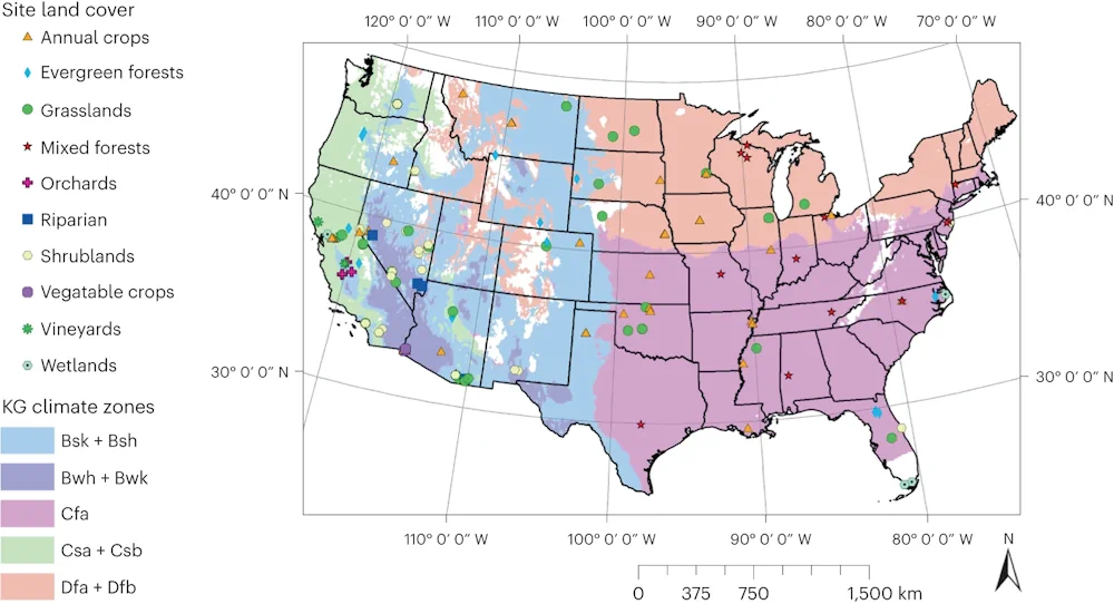
This tool has the potential to revolutionize water management, allowing for field-scale operational monitoring of water use, and a new study provides a thorough analysis of the accuracy of OpenET data for various crops and natural land cover types. In the study, published in Nature Water, DRI scientists led a large team of researchers in a comparison of OpenET data to evapotranspiration data produced by 152 ground-based micrometeorological stations known as eddy covariance flux towers.
“One of the biggest questions for users of OpenET data is how accurate it is, given the magnitude and implications of the use of the data for water resource management,” said John Volk, Ph.D., lead author of the study and assistant research scientist and software engineer at DRI. “A lot of groups want to know what the expected rates of error are in agricultural lands, so that’s the major question that we wanted to address for this paper.“
The eddy covariance stations consist of instruments and techniques for calculating the flux of trace gases, like water vapor, coming off the land surface. They offer one of the best methods for quantifying evapotranspiration on the ground, Volk says, which provided the researchers the opportunity to compare the ground-based observations with those provided by satellites.
Each station’s data was compared to the OpenET model ensemble, which combines six different Landsat-based models to produce an average, as well as data from each individual model. Then, the stations were grouped by land cover type and climate zone to assess how the accuracy of OpenET data changes across these variables.