The University of Córdoba is participating in the creation of the first database that harmonizes the recording of disturbances caused by insects and diseases in forests in 8 European countries by combining remote sensing, satellite images and field data.
Forest damage caused by insects and diseases is increasing in many parts of the world due to climate change as reductions in plants’ defense mechanisms, induced by global warming, seem to contribute to forests’ increased vulnerability to the incidence of pathogens and diseases.
These disturbances jeopardize many of the beneficial effects that forests offer the world, such as carbon sequestration, the regulation of water flows, wood production and the conservation of biodiversity. Having a complete and harmonized map of what these disturbances are and have been in Europe is essential to be able to understand and anticipate future incidents, thus protecting forests and their advantages.
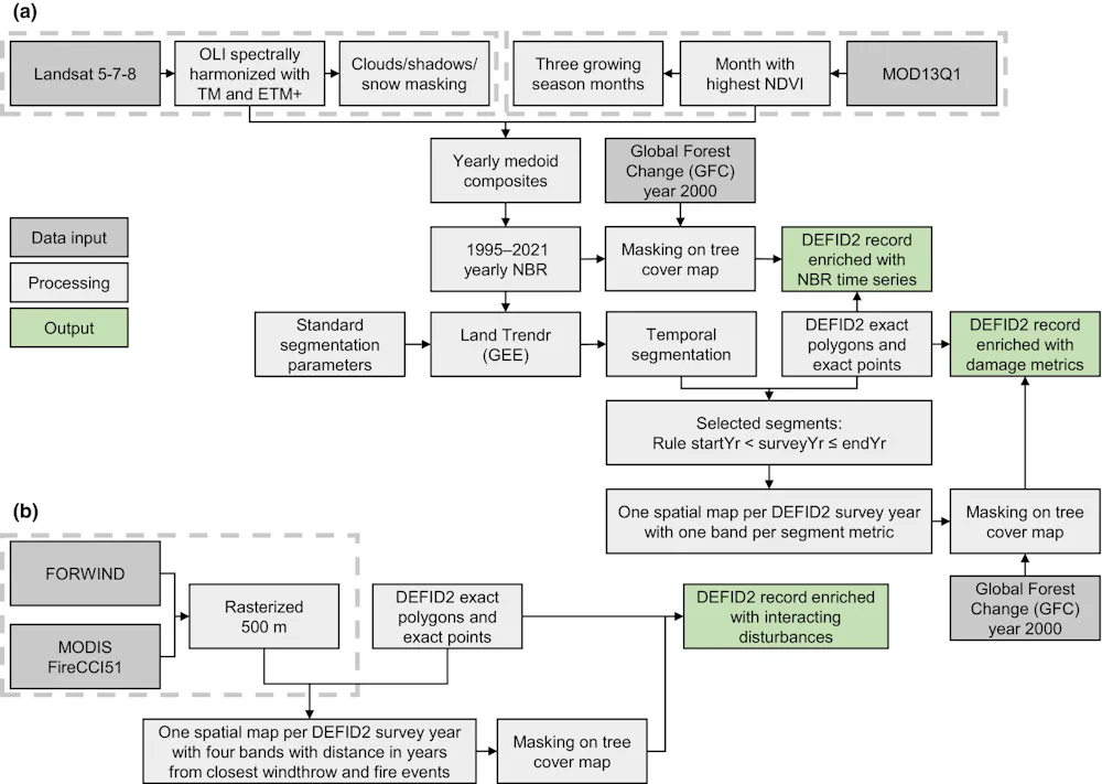
This unified European registry did not exist until now. An international team coordinated by the Joint Research Centre (JRC) of the European Commission, on which Rocío Hernández and José Luis Quero, researchers in the Department of Forest Engineering at the University of Cordoba, have worked, has developed a new spatially detailed database on disturbances caused by pathogens and diseases: the Database of European Forest Insect and Disease Disturbances – DEFID2.
The database contains more than 650,000 harmonized georeferenced records, mapping insects and diseases occurring between 1963 and 2021 in European forests. The records currently cover eight different countries and were acquired through various methods, such as land surveys and remote sensing techniques. Records in DEFID2 are described by a set of qualitative attributes, including the severity and patterns of damage, pathogens, host tree species, climate-driven triggers, silvicultural practices, and eventual health interventions. The database is complemented by Landsat Normalized Burn Ratio time series satellite data of the affected forest areas, an index very sensitive to abrupt changes in vegetation that allows one, through images, to see the onset, duration and magnitude of the disturbance.